The adventure category includes trips and hikes to fantastic places around the world and in nature. It also includes trips and hikes looking for new perspectives on everyday things.
Should I write about the ordinary ones? The lousy ones? Like a good picture of a bad thing? Is my job to filter out the dismal or only filter out the low quality? You’ve been warned.
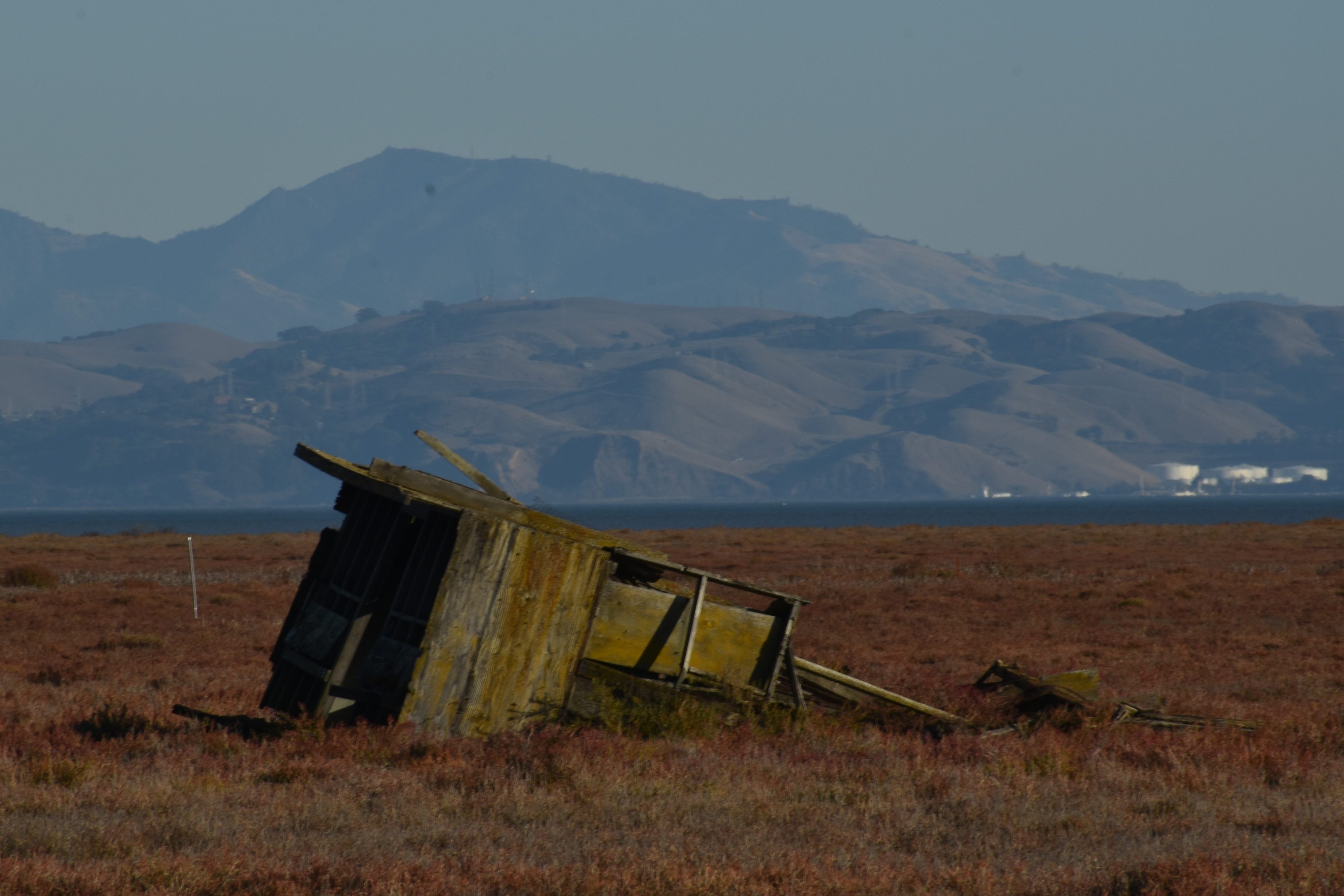
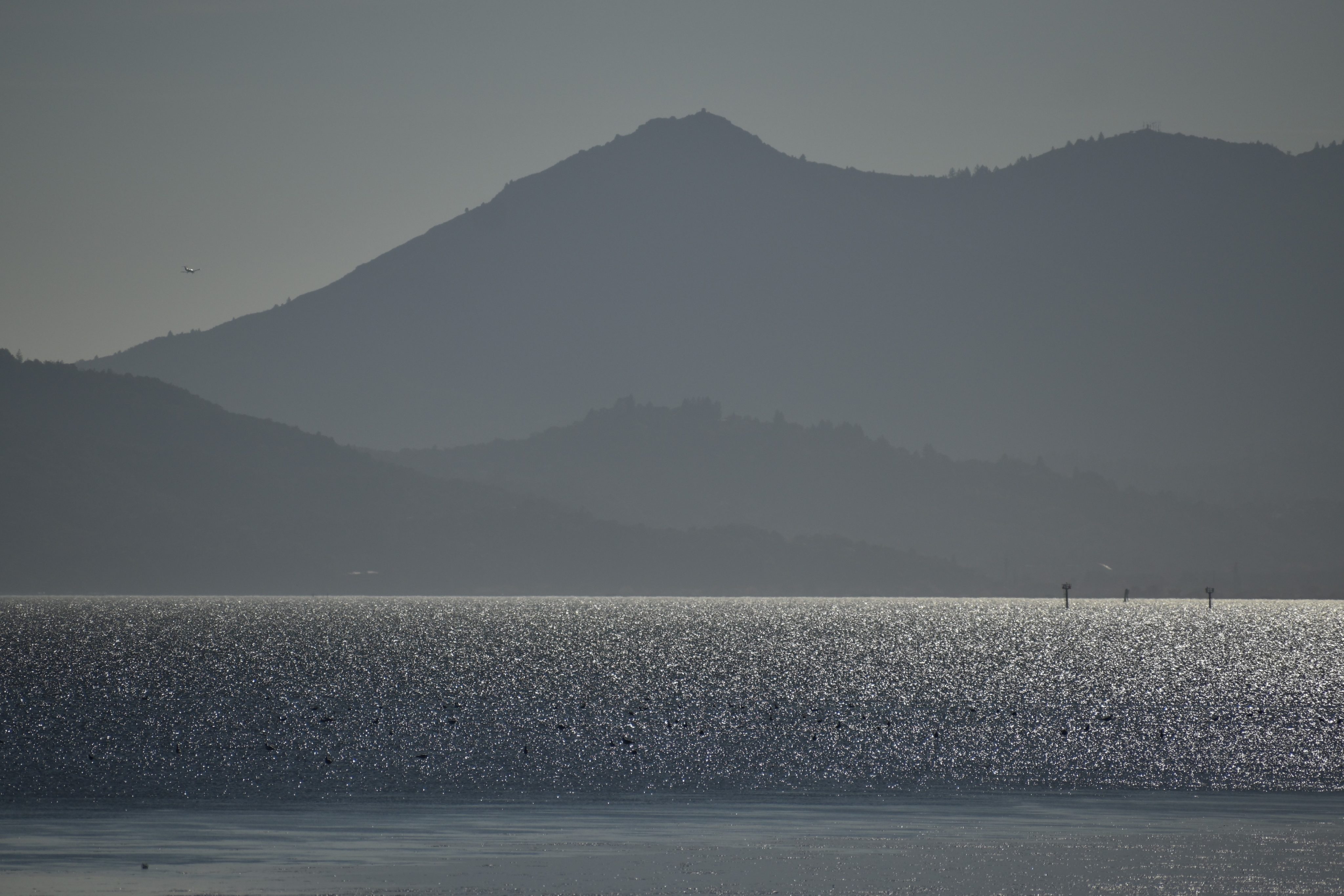
What I wanted was pics of exotic shorebirds and ducks at the National Wildlife Refuge. What I got was a weed-lined tractor trail with two and a half miles worth of an endless pickle weed patch on one side and nothing but overturned dirt on the other, set to a backdrop of an endless parade of truck traffic on the 37, in a bowl of distant mountains and urban skylines.
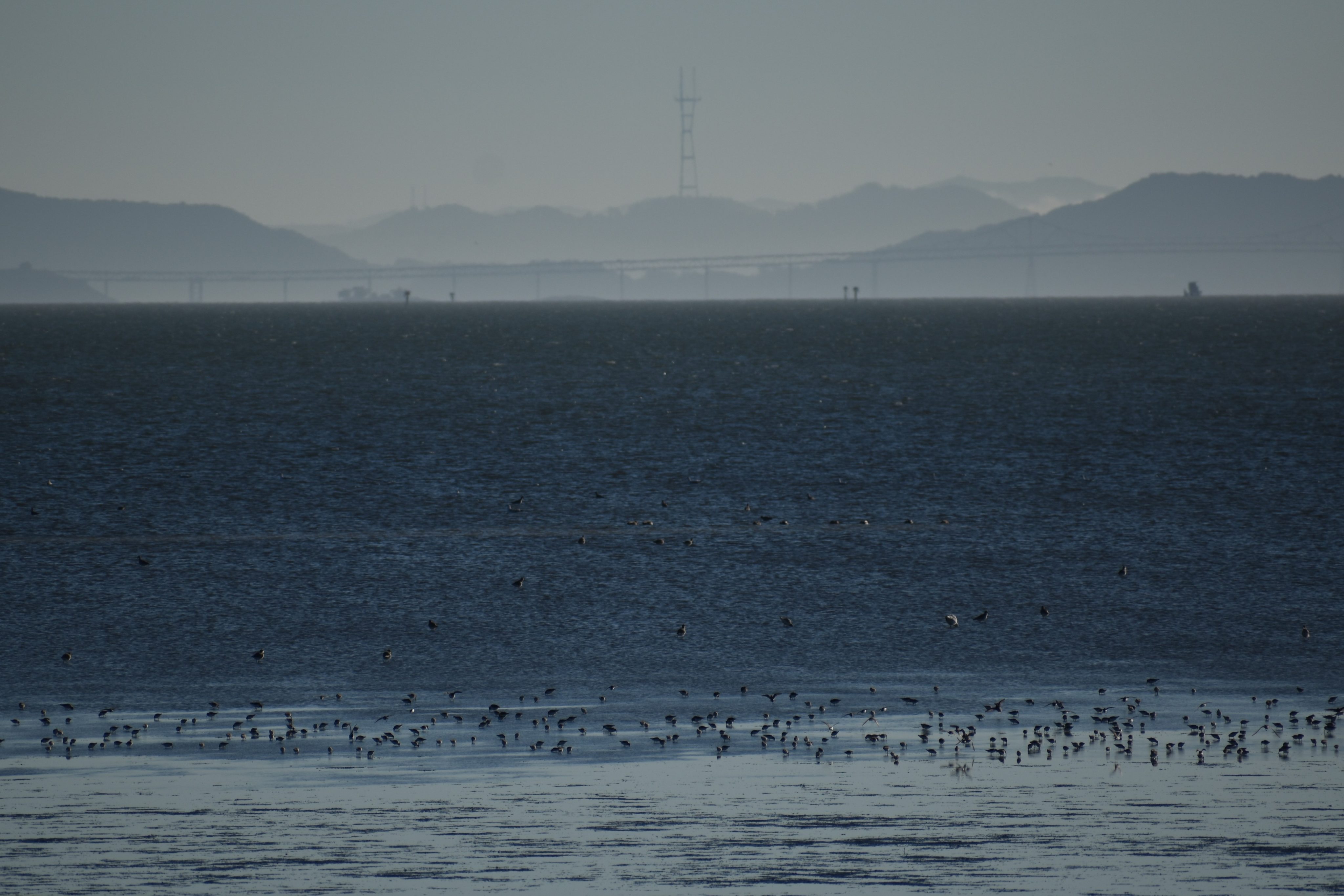
I followed the tractor trail two-and-half miles to the water of the North Bay. The bushes at the trailhead were littered with tp, looking mostly like a place to pull off the highway and to take an emergency crap. I was hoping that eventually, I would come upon tidal, bird-infested waters. Instead, I side-stepped spent shotgun shells with the remains of a metal carcass, passed by an abandoned structure of some kind, pondered a very lost and large cement block, and covered my nose with my face mask hoping to block out the odors of a foul-smelling ditch. When I arrived at the most northerly point of the North Bay at low tide, I witnessed nothing more than mudflats and vanishingly small birds in the tidal distance.
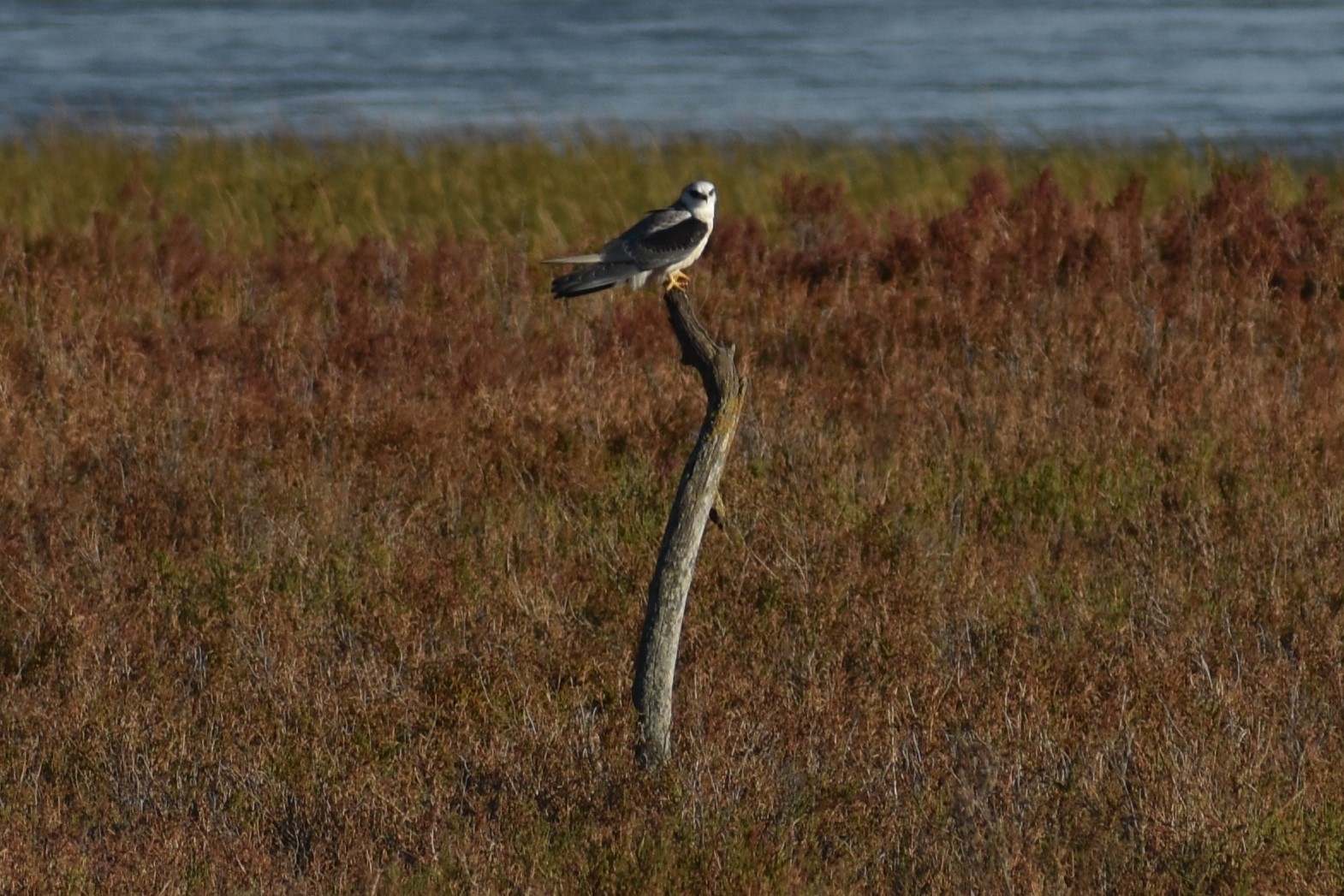
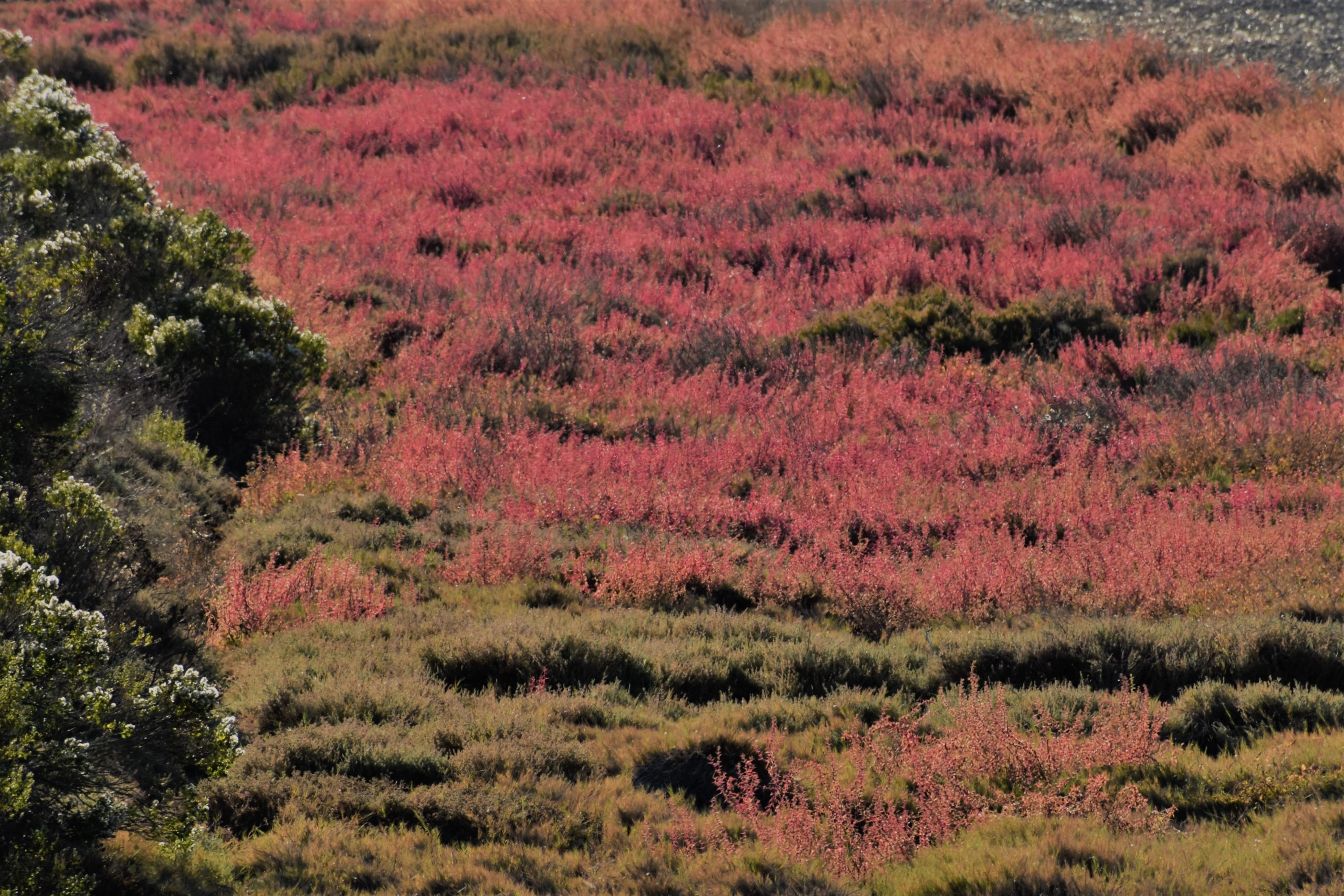
Trying to make lemonade out of lemons, the temperature was perfect and there was barely a cloud in the sky. Even weeds can be colorful with interesting shapes. The junk piles make for semi-interesting compositions embedded in the pickleweed and a horizon of hills. A kite stopped on a stump protruding ever-so-slightly above the terrain. Two deer ventured out onto the barren fields from a small weed patch. I wondered if deer have ankles to twist as they retreated back at the sight of me over the clumpy dirt to their weedy home, probably confused as to why a person was on the trail at all. As I walked, I drove flocks of songbirds in front of me from one weedy perch to another, apparently not sharing my dim view of the seed-sated weeds.
I often wonder when I hike alone what would happen if I keel over. On this one, I don’t think anyone would chance upon me until the next planting season when some hapless farmer would wonder what that crunching noise was under his big fat tractor tires. I would have expired within sight of the highway with the indifference of nothing more than roadkill. I’ve hiked in remote places with more people than this trail (none). I was close enough to see yet far enough never to be seen.
I felt dirty when I was done, like negotiating with a used-car salesman. It was an ugly hike. As you may suspect, I don’t recommend it. But keeping people away may be just what the birds need.
In my head, I planned on a challenging hike but as the day wore thin, I settled on the familiar territory of the North Shore of Lake Hodges choosing to focus more on exercise than on photography. Nevertheless, I follow the first rule of photography, always have your camera ready, even though your expectations are low.
As I start the hike, a man passes by asking me if I am “Gitten any?” My camera is strapped over my shoulder, and I know what he means, but the immediate in-my-head response is, “not in a long time.” I actually respond with the truth from all perspectives. “Trying.”
I have a couple of hours before sunset, so I decide to walk the upper rim of the Lake Hodges Canyon to see if it meets up with the trail to the summit of Bernardo Mountain, which I know would take me back to the main trail, preferring a loop trail to an out-n-back anytime. I tried once before but ran out of daylight and had to head back the same way I came.
The problem with the overlook trail is that it is marked obsessively with “No Trespassing” signs. According to the signs, the truck trail is for access to sewage lines by the water authority people only. The tire tracks of a hundred mountain bikes say otherwise. So do other signs that say we grant you passage as long as you don’t sue the pants off us for your issues. So I pin my water authority badge to my chest and march on.
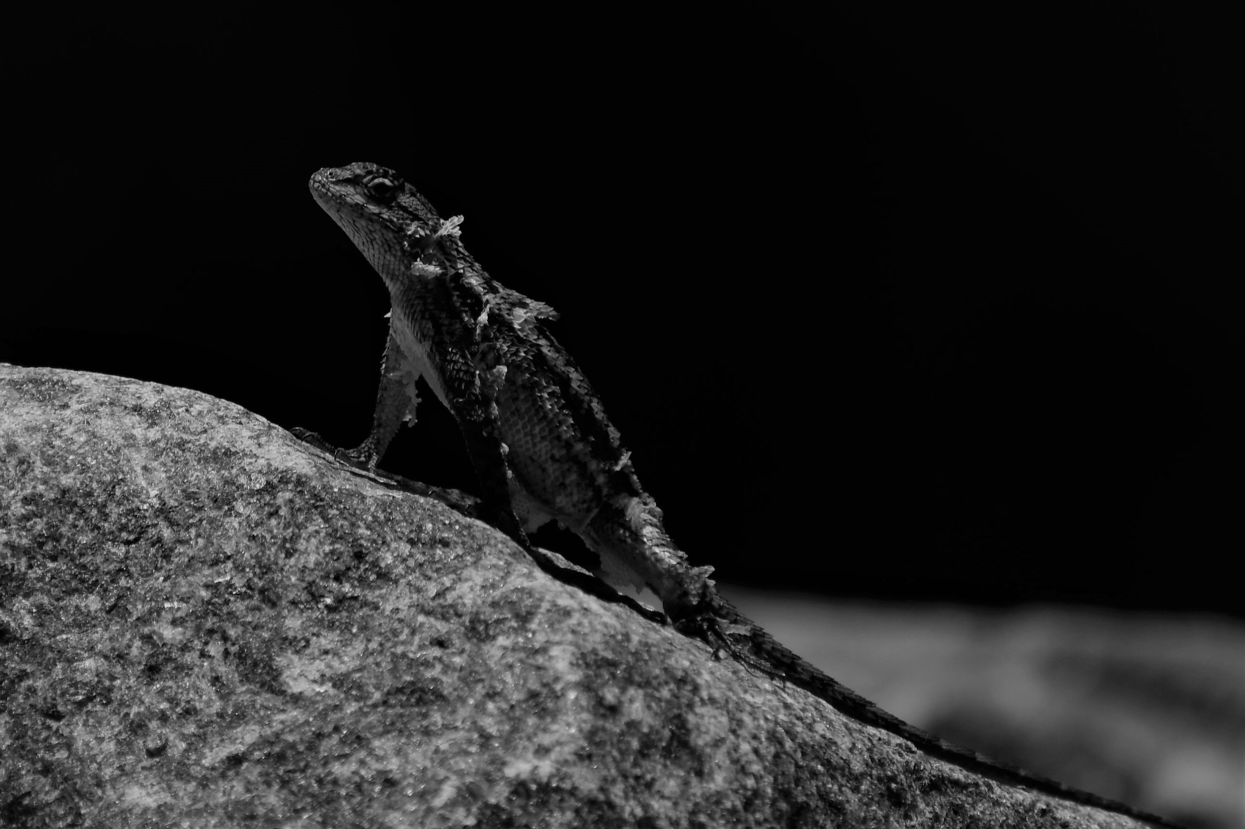
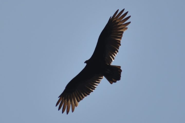
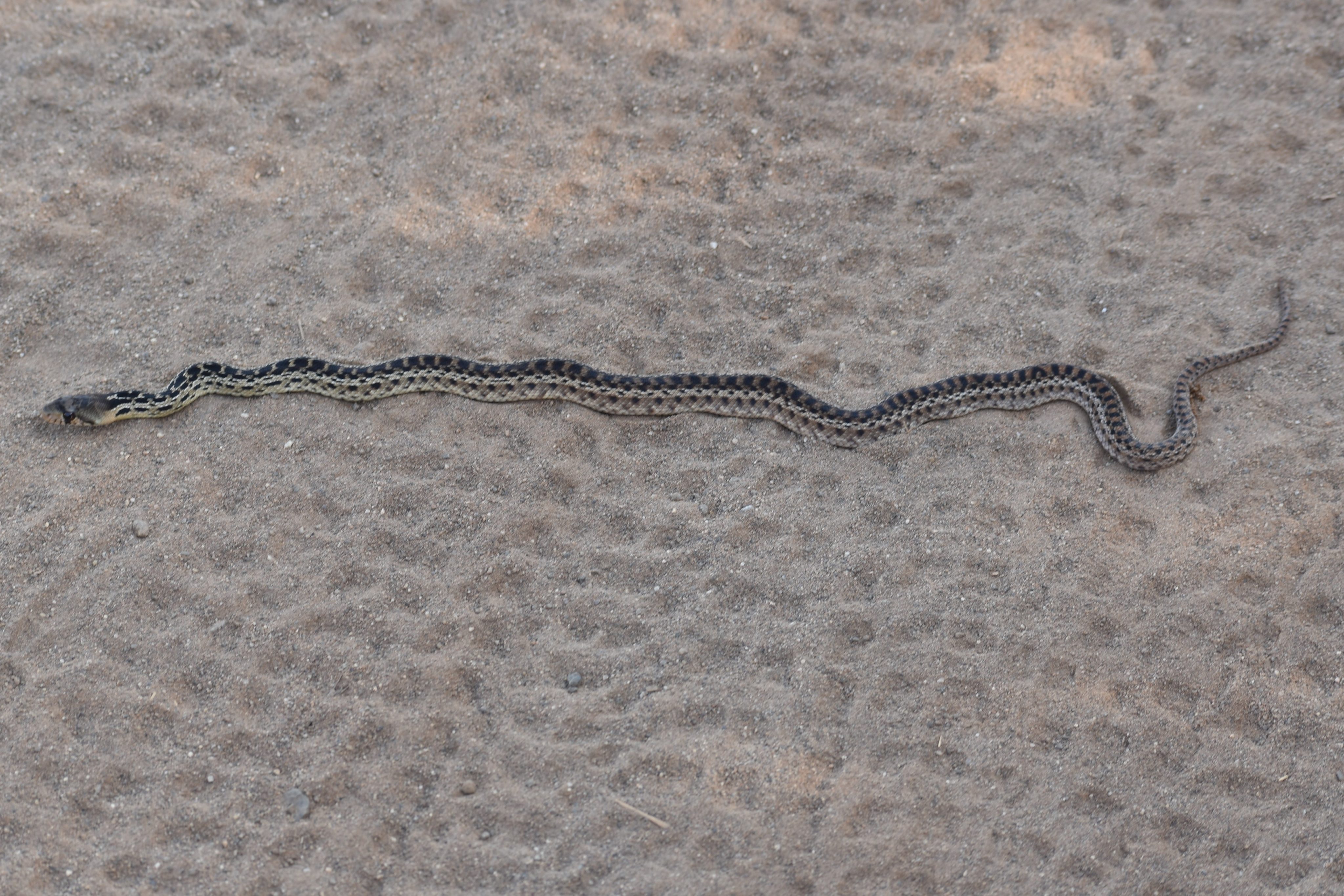
A turkey vulture circles overhead playing tag with the sun, at least from my ground perspective, as he rides the thermals. A small two-foot gopher snake, with its spotted backside, almost matching the dimpled patterns of the bike tread stretches across the truck trail. It doesn’t seem too perturbed by my presence, which is a little bit worrisome, because if it stays stretched across the road for any length of time, the patterns on its back will become an exact match to the treads of an unwary mountain bike. I try to get a picture of it forking its tongue at me but the critter is uncooperative. I held the camera in place for a hundred count a couple of times. Of course, as soon as I gave in, the uncooperative creature forked its tongue at me. I finally gave up and moved on, the day not growing any longer on my account.
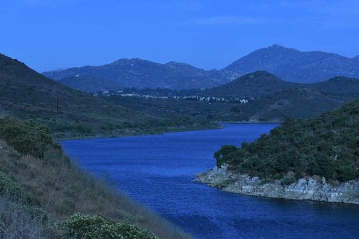
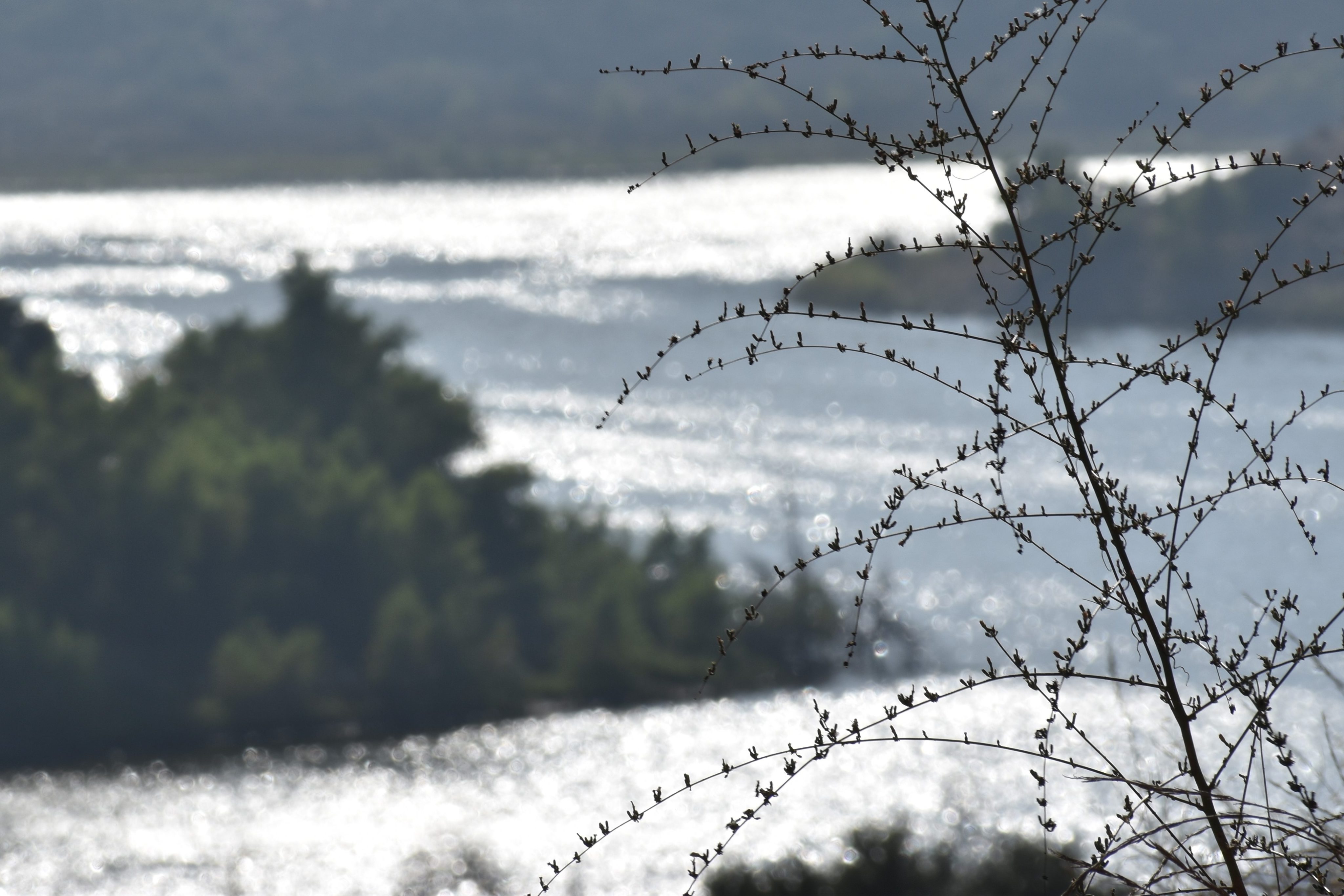
A little way down the trail, the sparkling sunlight off the lake catches my eye, inspiring me to try to capture a blurred bokeh with the glint of the snaking lake in the background. Lake Hodges is a dam lake that follows the curvature of the San Dieguito River canyon.
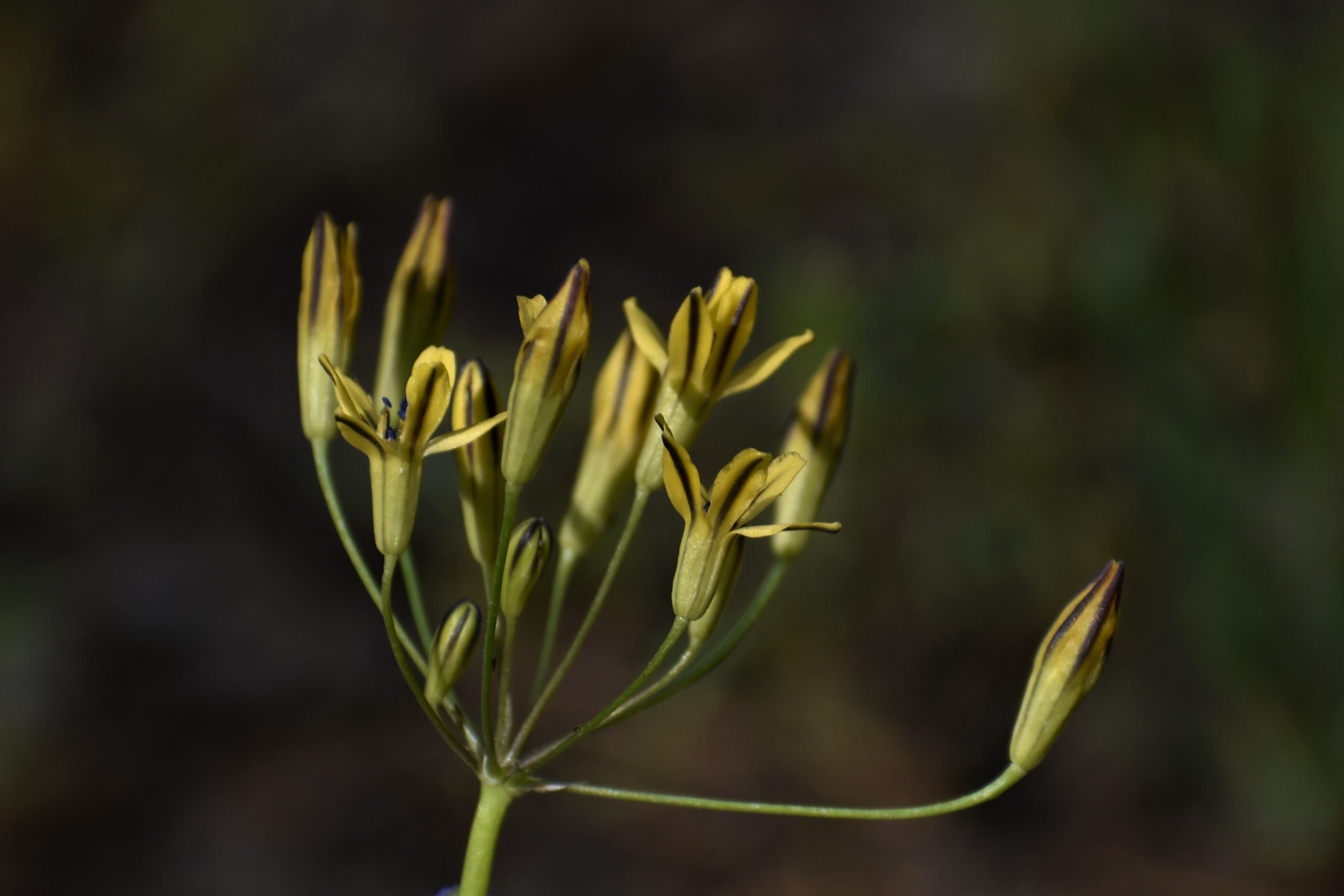
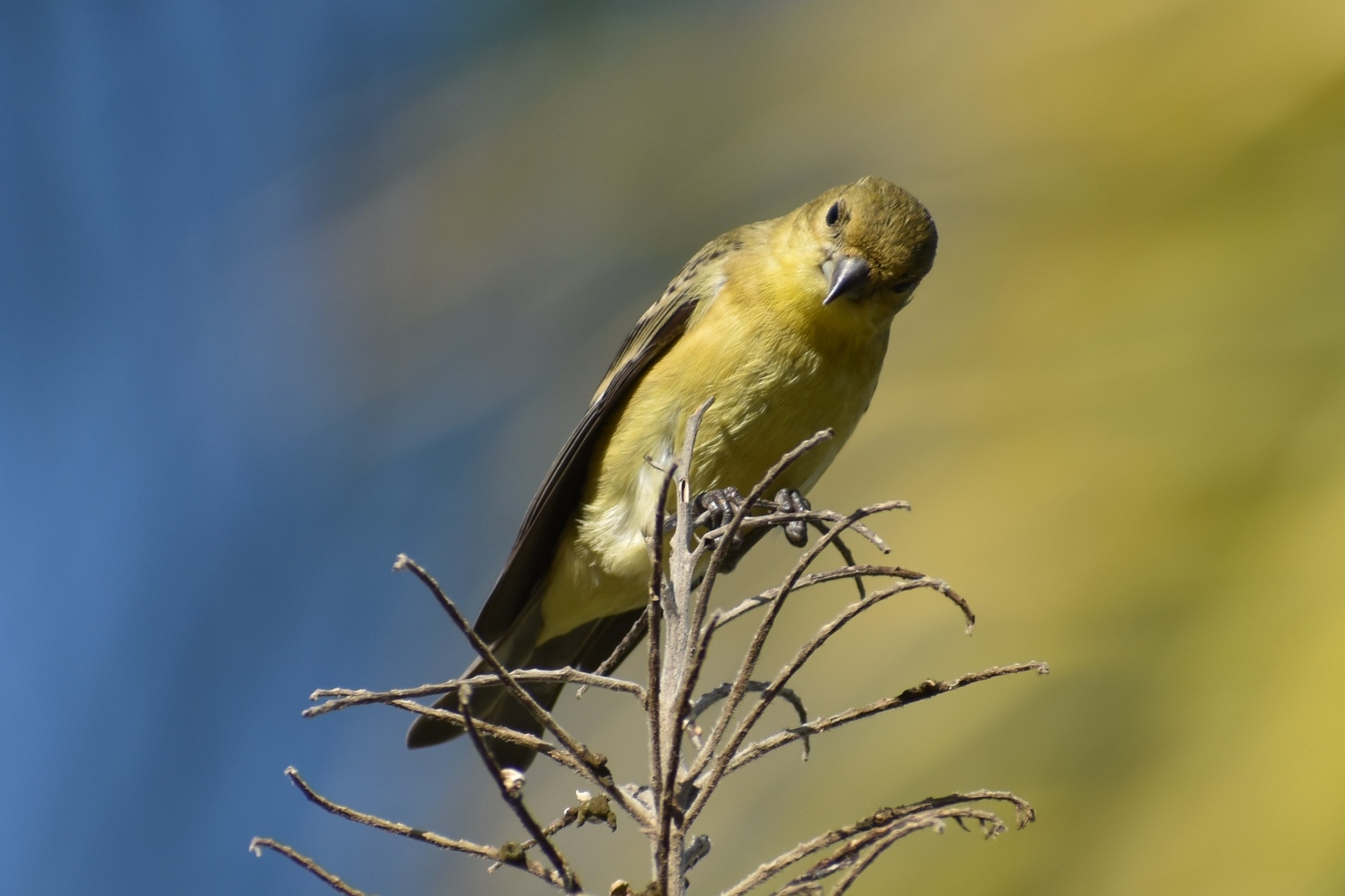
On a previous outing, near this spot, I came upon a roadrunner being harassed by a mocking bird. Instead, I find a tree full of lesser golden finches. Lesser than what and by whose standards, I don’t know and they are not telling.
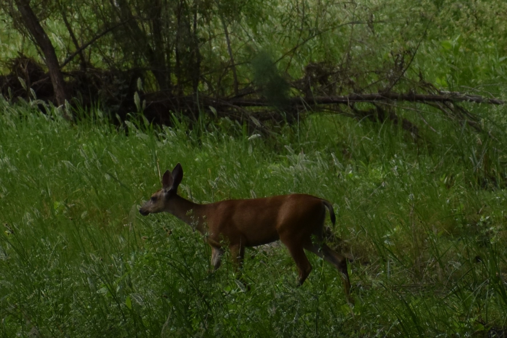
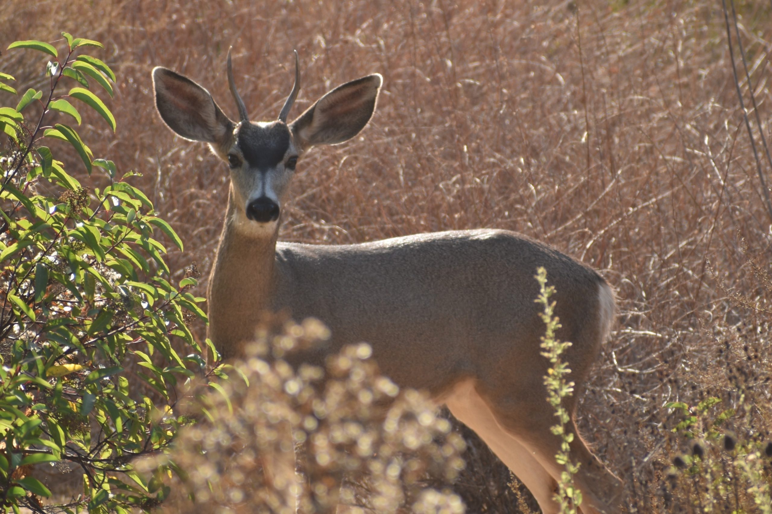
I push on. As I round a corner, I see a mule deer on the road. It surprises me to see one so out in the open. His antlers are just starting to come in. This is the second sighting of mule deer I’ve seen in two weeks. I’ve been hiking in San Diego County for forty years and I’ve seen at most twenty-five in all that time. I’ve never seen any in this area before. He lets me get a little closer before diving into the bush. He gives me one last look over the shoulder to see what my intentions are. My intentions are to take advantage of the photo op.
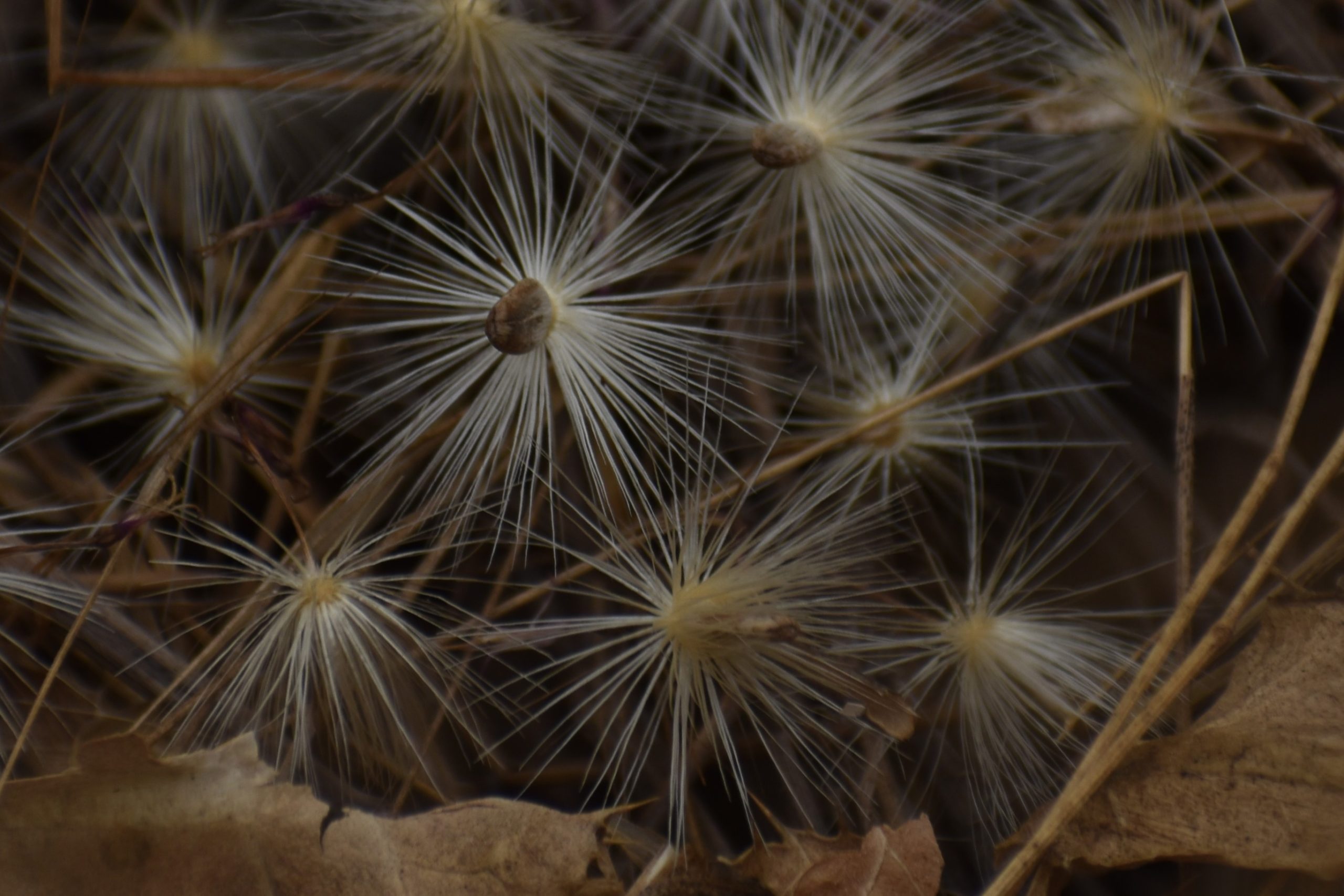
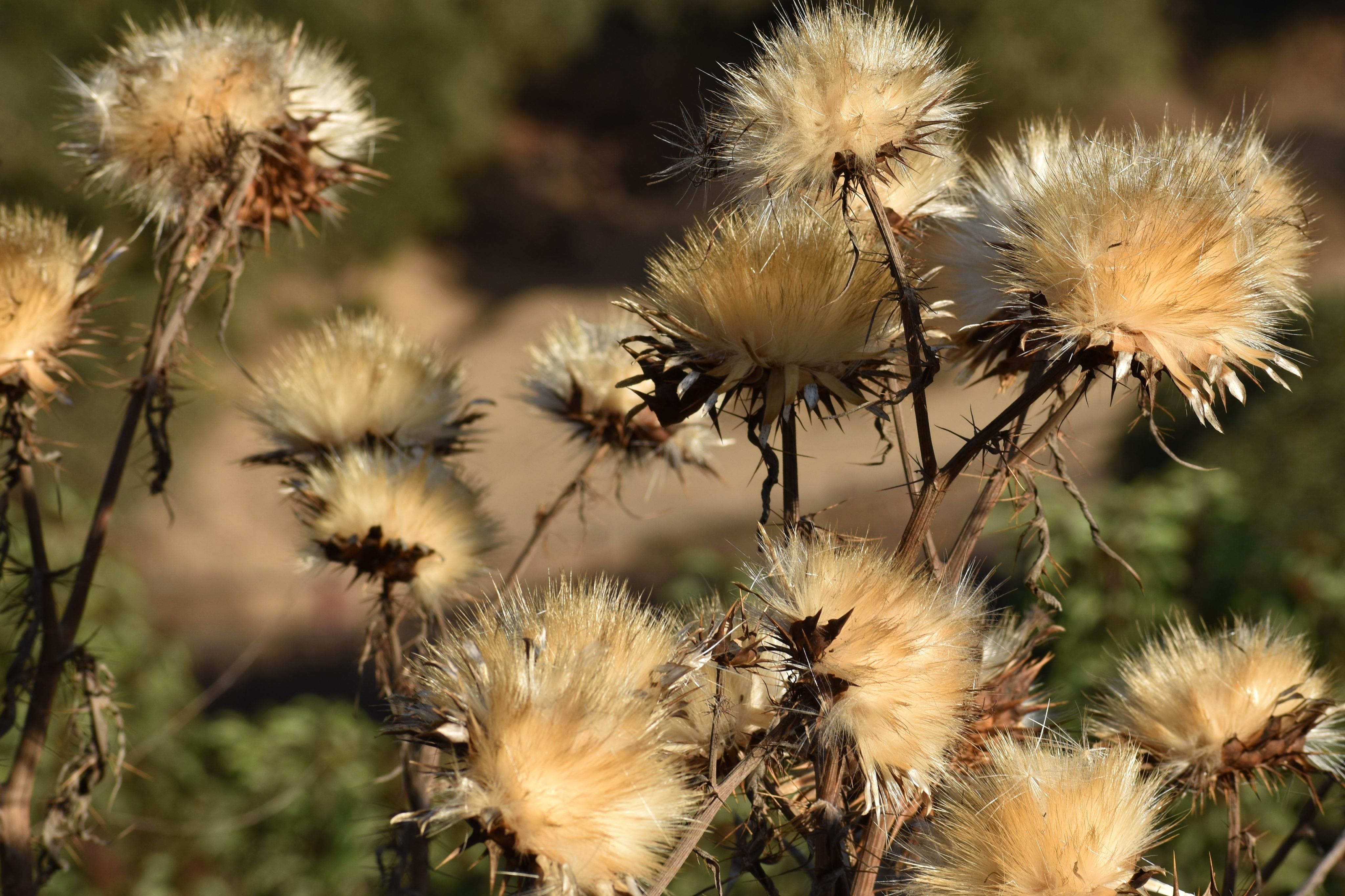
The sewage access road turns into a driveway but a single track trail dives into the riparian woods surrounding a small creek that feeds into the lake. I take the trail and I’m pleasantly surprised when I end up on the flank of Bernardo Mountain, not quite as far into the mountain access as I envisioned but happy when the trail emerges onto the Bernardo Mountain trail. I don’t have to do an out-and-back. I snap a few thistle remains, still photogenic in my mind, even without their brilliant neon blue day-glow flowers.
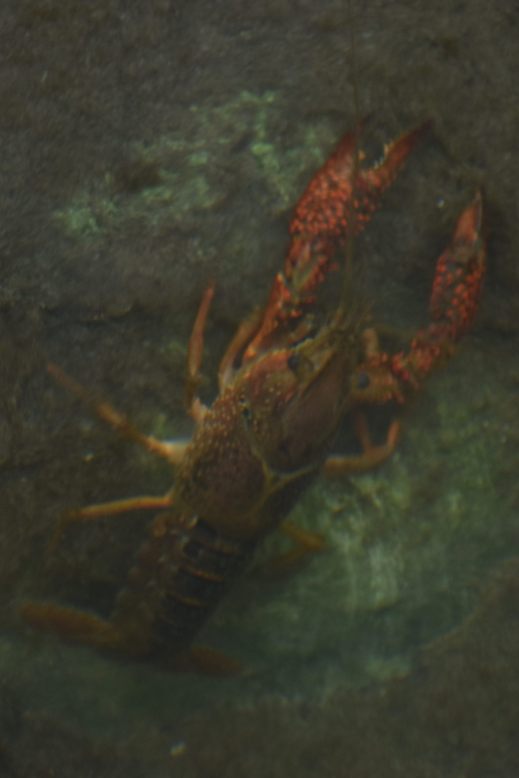
I rejoin the main trail that traverses the length of the North Shore interrupted only by a couple of crayfish, or do you say crawdaddies, at the creek re-crossing on the main trail. I didn’t expect much on the way back other than a lot of bike traffic. I stopped to take a failed photo of a very Suessian orange and white buckwheat flower shaped like a soccer ball or a flavorful dangling lollipop.
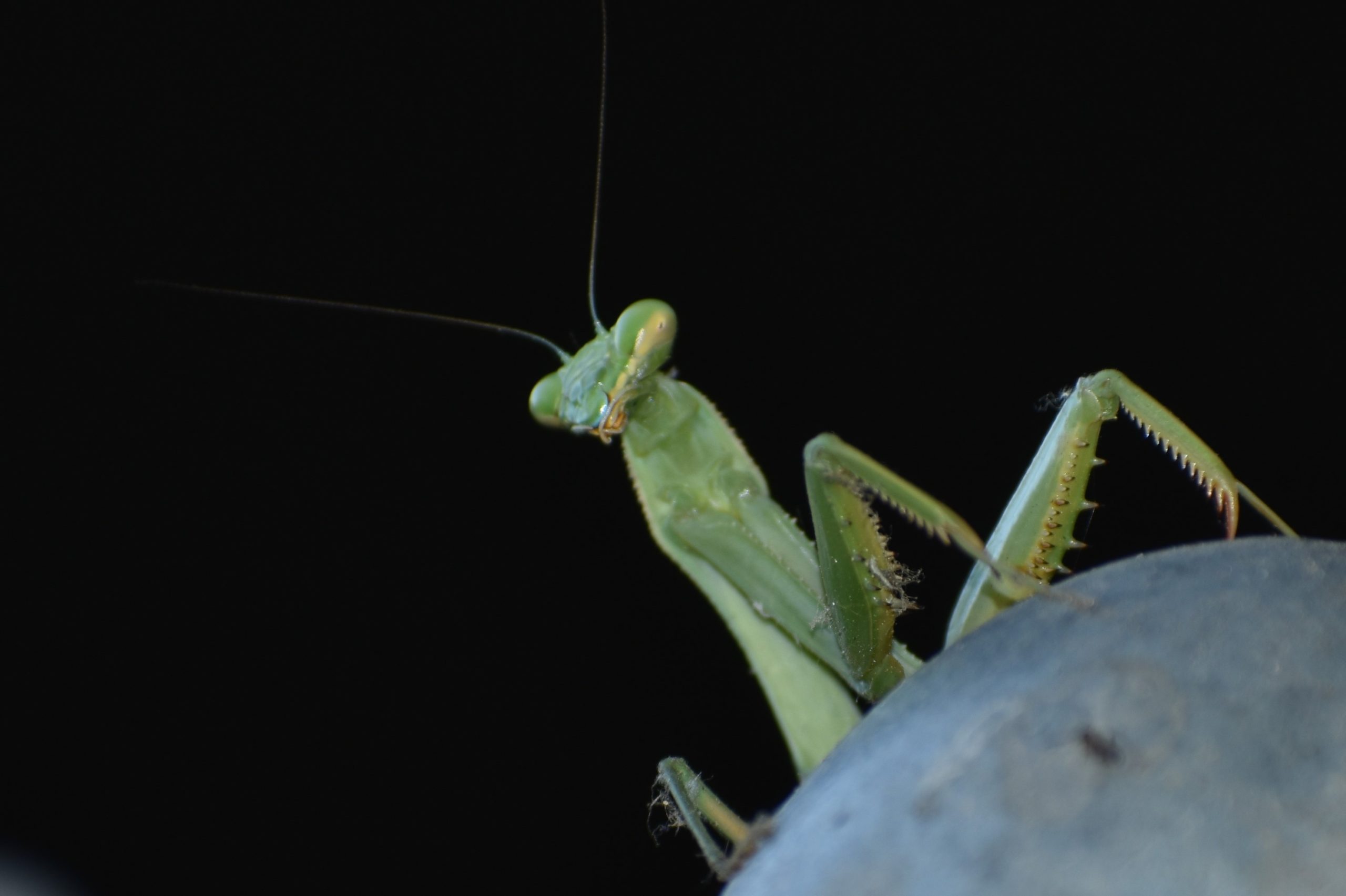
As I walked under the I-15 expressway, I checked under the bridge to see if any swifts were out and about from their mud nests that hang under the eaves. Instead, I had an encounter with a praying mantis hanging out on the top of a post of a chain-link fence. He thrust and parried a few times to chase me off but then went back to his praying.
With a snake, a deer, a praying mantis, some landscape, and some previously undiscovered trail, I remembered the guy I met when I started the hike. Yeah, I got me some!
As if an unwanted birthday wasn’t enough, my twenty-seven year old, freon compressed, central A/C decided to die of bad capacitance and a burnt-out motor a day before the two weeks of 100+ and 110+ degree weather. A subject matter expert came out to give me an estimate on a replacement unit. As he inspected the bowels of my house and noted problem points, he doubted the efficacy of my A/C efficiency to the tune of about 10K.
With the demise of the A/C, my living space was reduced to the inner sanctum of a single 10x10x8 room that contains all my connections to the outside world: the temporary room AC, the TV, the work laptop, the personal laptop, and the iPhone. I once read that the entire biomass of humanity individually put in 9x9x9 cubic foot containers could be stored inside the Grand Canyon. I don’t know if that is still true or not because the population has expanded by a few billion people since I was informed of that fact. I don’t think the Grand Canyon people-fill generated a lot of enthusiasm in the real estate market.
At work, dumped from two projects this year and waiting four months and counting to start a new one while COVID drove everyone from their offices to their homes, my living space also turned into my workspace. With time on my hand and inspired by the insane politics of the time, I read Hannah Arendt’s book “A Report on the Banality of Evil.” In the evilest empire of modern times, people hid behind platitudes. State a positive to overlook a negative. The road to hell is paved with platitudes. That is the banality of evil. I’ve had months to contemplate the platitude that made my pending work assignment once palatable, “Peace through Strength.” My workspace feels really small.
COVID had me in storage. Work had me in storage. An oppressive heatwave had me in storage. Regardless of the venue and with a milestone birthday imminent, I for one wanted out of storage. I decided to take the week off from work to get my head around my descent into decrepitude and to evaluate the efficacy of my own efficiency. Somebody called it a symbolic milestone, but the symbolism escapes me. It feels pretty real to me.
So what do you do for your symbolic milestone birthday in the age of COVID to get out of storage? Road trip! Particularly when you have Hetal and Chris for friends. Separate cars! Separate rooms! Stay outdoors wherever possible. Masks and hand sanitizer. We were going. As Hetal said, birthdays are a big deal.
We went!
The general plan was to head to Sequoia National Park and Kings Canyon National Park. The reason for this particular destination was my desire to visit Kings Canyon. I’ve seen Kings Canyon from a distant overlook and technically, I’ve been in the park before because of the small isolated piece of it on the road to Sequoia that contains General Grant. I’ve never made it into the canyon proper mostly because I have visited the area in the offseason on late-year holiday trips when the only drivable entrance to Kings Canyon is closed off. Not at all complaining about the beautiful overlook into the canyon but just seeing it from the rim is a teaser, like flying over in an airplane. If you go to one park, it is a wasted opportunity not to visit the other if you can, so Sequoia is in the mix even if it is a several time repeat.
I was strongly advised to get reservations for a campground because of COVID constraints and crowds. Indeed, my search through the campgrounds proved them all to be full and the first-come, first-serve campgrounds closed on account of COVID. So I made reservations at Eshom Campground in Sequoia National Forest, which looked pretty close to the parks on a small map. This was the part of the trip I did plan in advance.
During an unrelated astronomical conversation concerning the identification and alignment of planets, the topic of the trip came up with Phil, a lifelong friend I met at the age of 9. A potential hike I was considering to Mist Falls was also on Phil’s to-do list. So he would be joining us for a night of camping and a day of hiking in Kings.
I packed my car full of camping equipment, coolers, and clothes. I chose Stephen King’s “On Writing: A Memoir on the Craft” on audio for company. Listening to King on the way to Kings seemed fitting. The reservations were for Sunday and Monday. We left on a Saturday. We had an unplanned night before the visit to the National Parks. When Chris and Hetal showed up at the house, I still wasn’t sure where we were going first.
I offered up the idea of the Kern River but the final decision was Ojai with the possibility of continuing onto Paso Robles. It wasn’t a completely random destination, we had discussed it at the beginning of the summer for a possible motorcycle trip but the stars and planets didn’t quite align. In a previous motorcycle trip through Ojai with a different crowd, I did little more than take a quick lunch break before cruising through the picturesque Los Padres National Forest on CA-33 on our way to Paso Robles and beyond.
While Stephen King struggled through his childhood for the next couple of hours and without any hint of what his rambling had to do with the craft, I began a text-while-driving negotiation to meet Ann who lives in Ojai, a friend I haven’t seen in the six months since we collectively went into storage back in March, to give her fair warning of our impending arrival instead of just showing up at her house and telling her “Surprise, we are here!” Not so much because I’m courteous but only because I don’t know with any precision exactly where she lives. Even in COVID, LA traffic accommodates my texting session with stopped traffic in the middle of the freeway for no other apparent reason than to allow me to continue my conversation without the risk of driving. Over the course of the four-hour trip, I learned that Ann will meet us somewhere for dinner after she finishes painting houses in Ventura.
After nearly four hours of talking, Stephen King is still only five years old in his memoir. I suppose five was a watershed moment in my life too, but all I have to say about that is you can’t trust old people. I think I could make a case for that lack of trust setting me off on a youth filled with long hair and informality and iconoclasm and introversion. With any luck, in five or ten years, I can inflict you with my own memoir on the craft so you can judge for yourself if my case has any merit.
Ojai is a tourist town and a gateway to the wilderness recreation in the coastal mountains outside of Ventura and Santa Barbara. The downtown has an adobe feel to it. Outdoor seating and drinking beckoned but our first stop was to Bart’s, the world’s greatest outdoor bookstore. Bookstores aren’t dead yet although it doesn’t hurt to have a quaint outdoor setting and a great reputation. I asked the kid at the register how they choose their books and he told me the books choose them. Fair enough. So I asked the books how they choose the store and each had its own story to tell. Haha. I couldn’t resist. Sorry.
We started our night on the town at the Ojai Pub. At Ann’s recommendation, we redirect to Topa Topa Brewing company where we finally meet up, and then from there to Ojai Beverage Co, all with outdoor seating and plenty of beer and food, a great way to spend a Saturday night. As much fun as I have in the inner sanctum of my personal storage drinking my homemade wine telling my dogs the errors of their ways, it just doesn’t compare to a warm night on an outdoor patio, eating someone else’s cooking for a change, and telling my interactive and three-dimensional and charming friends the errors of their ways. Ann is a gracious host.
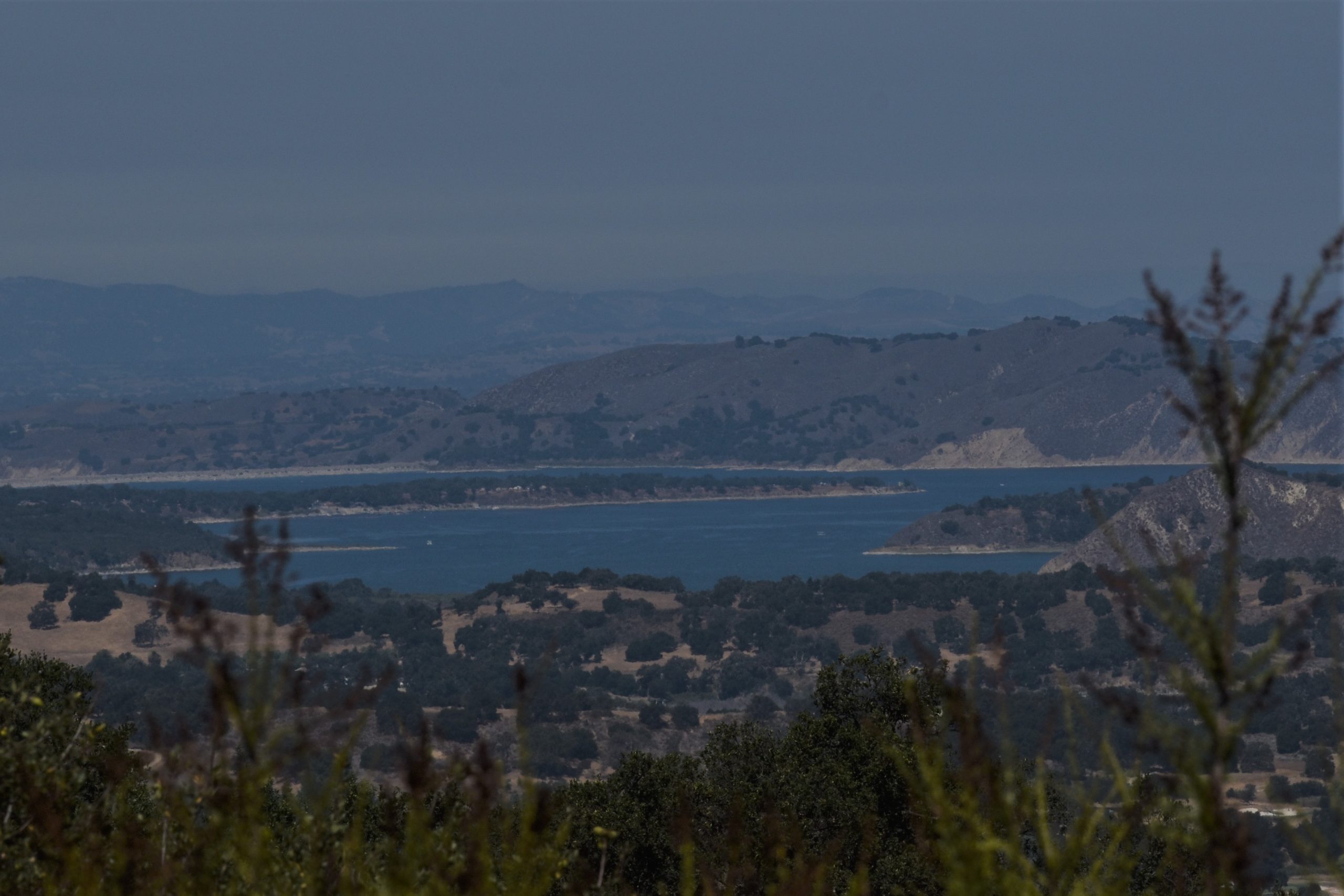
Cachuma Lake
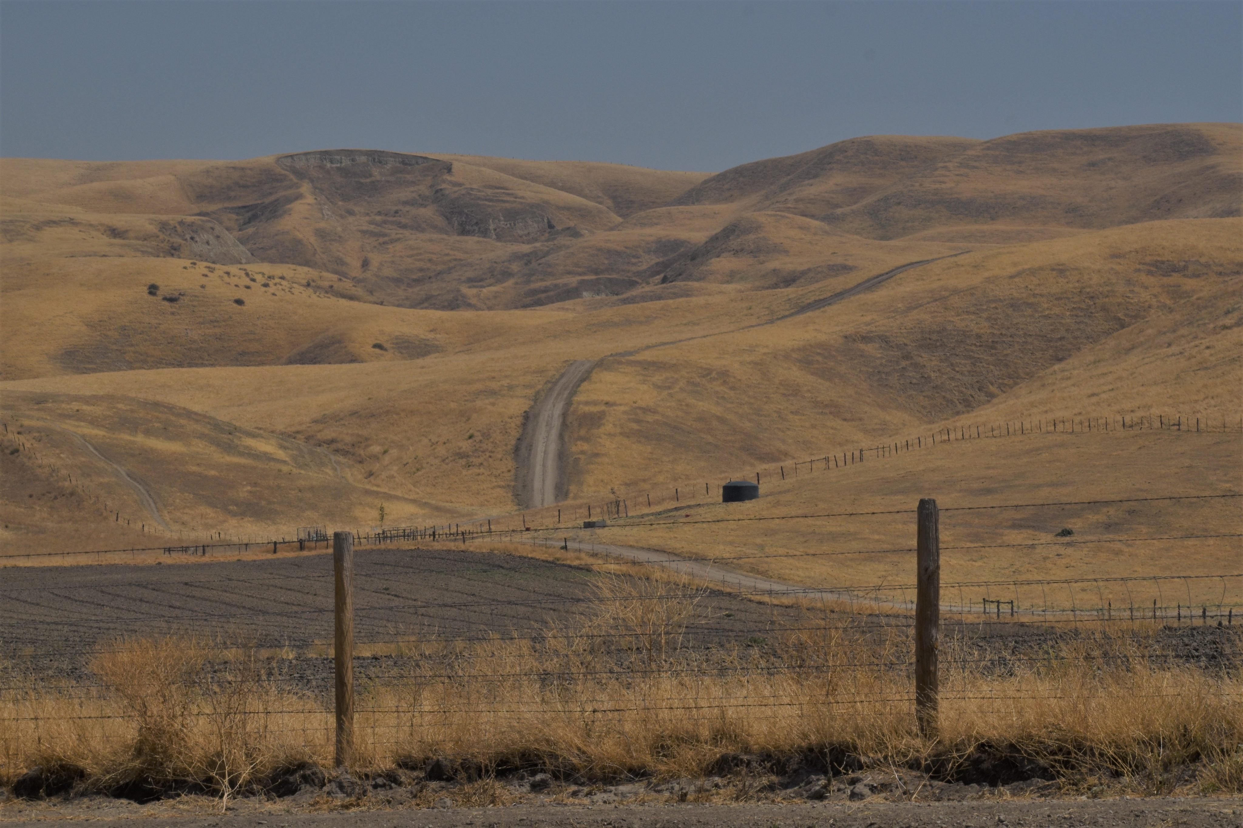
After an overnight in Carpenteria and a coffee at a coffee shop to which people coagulate on a Sunday morning on a downtown artery of Santa Barbara, we headed out the scenic 154 for a panoramic view of Cachuma Lake and an involuntarily slow drive-by of a smoldering blackened car. We crossed over from the coast to Visalia through the golden hills inside the coastal range outside of San Luis Obispo. The yellow, gold, and tans with just an occasional splotch of tree were painting and picture waiting to happen.
Hills of Yellow, Gold, and Tan
Stephen King has been chatting me up as we cut across the state still talking more memoir than craft. He finally gets around to the topic of writing. He hates adverbs, I recall ruefully. He vigilantly culls his drafts for adverbs, but even he cannot purge his work of them all successfully. The road to hell is paved with adverbs, he says angrily and bitterly and ardently and abjectly. Abjectly sounded good when I wrote it but I actually had to look up its definition. Stephen hates pretense. Don’t fluff up your sentences with pompous and pretentious and supercilious and resplendent words that you don’t know the meaning of just to sound more erudite and educated.
He tells me half of writing is vulnerability. Stick your jaw out there, it will most certainly get punched. So far, when I’ve put my jaw out there for the punch, I’ve been hit hard by the harsh hands of irrelevance and invisibility and a complete lack of marketing skills. Needless to say, the other half of writing is about paying the hospital bill.
It pains me to no end that my fifty IG posts average about five hits compared to tens of thousands of hits in a single post of a hot babe in a pretend bikini telling me that life is an adventure. On second thought, maybe the other half of writing is about paying the shrink. In either case, my book sales to date won’t cover the cost for the phone call to set up the appointment.
Stephen ignores my pathos and moves on. It’s all about him. He lets situation drive his writing rather than plot. Plot is unnatural and forced and for him, at least, arises naturally from situation. Plot is emergent. Situation seems like an appropriate metaphor for a trip that was at least in part unplanned until its start day. Write this situation: what if we go to Ojai without a plan or a place to stay in the middle of a pandemic while the state is burning down?
In Exeter, we provisioned up at a little mom and pop grocery store that has only a mom and serves mostly the same fare as a gas station. The dairy section of the store is a single rack behind a glass cooler and there is no bread. But the lady is nice and sacrifices two sandwich bread loaves from her deli for our campout meals. In another encounter a day later, my vegetarian friend Phil stopped at a sandwich shop in Exeter and they gave him the Philly cheesesteak despite repeatedly clarify his order for something else. He’s pretty sure he could have ordered anything from the guy and he would still have ended up with a Philly cheese steak. So there you have it, the good and bad of Exeter. How many people even have the experience of being there?
From Exeter, we drove to our desolate campground in the Sequoia National Forest. We veered off to scenic back roads that narrowed into one car lanes and roughed ever bumpier and wound into ever tighter curves and bends. As the road turned to dirt, Google Maps told me, “Arrived.” I looked around. The only thing I saw was trees. In yet another unimpressive performance of the app, it had dumped me about a half a mile from the entrance to the campground. Google Maps once rerouted me in LA in the middle of the night down a freeway that ended, sent me into some dubious neighborhood, then cut out and dropped the image of the map while looking for its connection. I had no idea where the f**k I was. I once followed it in Idaho and it took me down a road that disappeared from the map while my impatient guide suggested over and over that I, “Return to the route. Return to the route. Return to the route,” as if it were my fault. They tell me AI is going to take over the world. Ha. Really? Wait. Now that I think about it, maybe that is one small step in its master plan.
Don’t fall for this cute face!
It didn’t take long to set up camp, then play catch with Chris and a real baseball, sneak glances at the two pretty lesbian (that’s how my mind processed it) girls in the campsite next to ours, and snap a picture of a gopher that looks like he is up for a game of whack-a-mole. Gophers at home have eaten far more from my attempts at agriculture than I have. Don’t let those cute buck teeth and that cute furry muzzle fool you for even a second. The road to agricultural hell is paved with gophers. And rabbits. And squirrels. And seed-eating birds. And snails. And insects. There is a lot of traffic on that particular road. It might work out for me if I trick the gophers into eating adverbs instead of corn and cucumbers.
Of course, I find my way into the alcohol and have a beer or four with my teetotaling vodka-drinking friend Hetal, commiserating over the last few minutes of my now spent middle age.
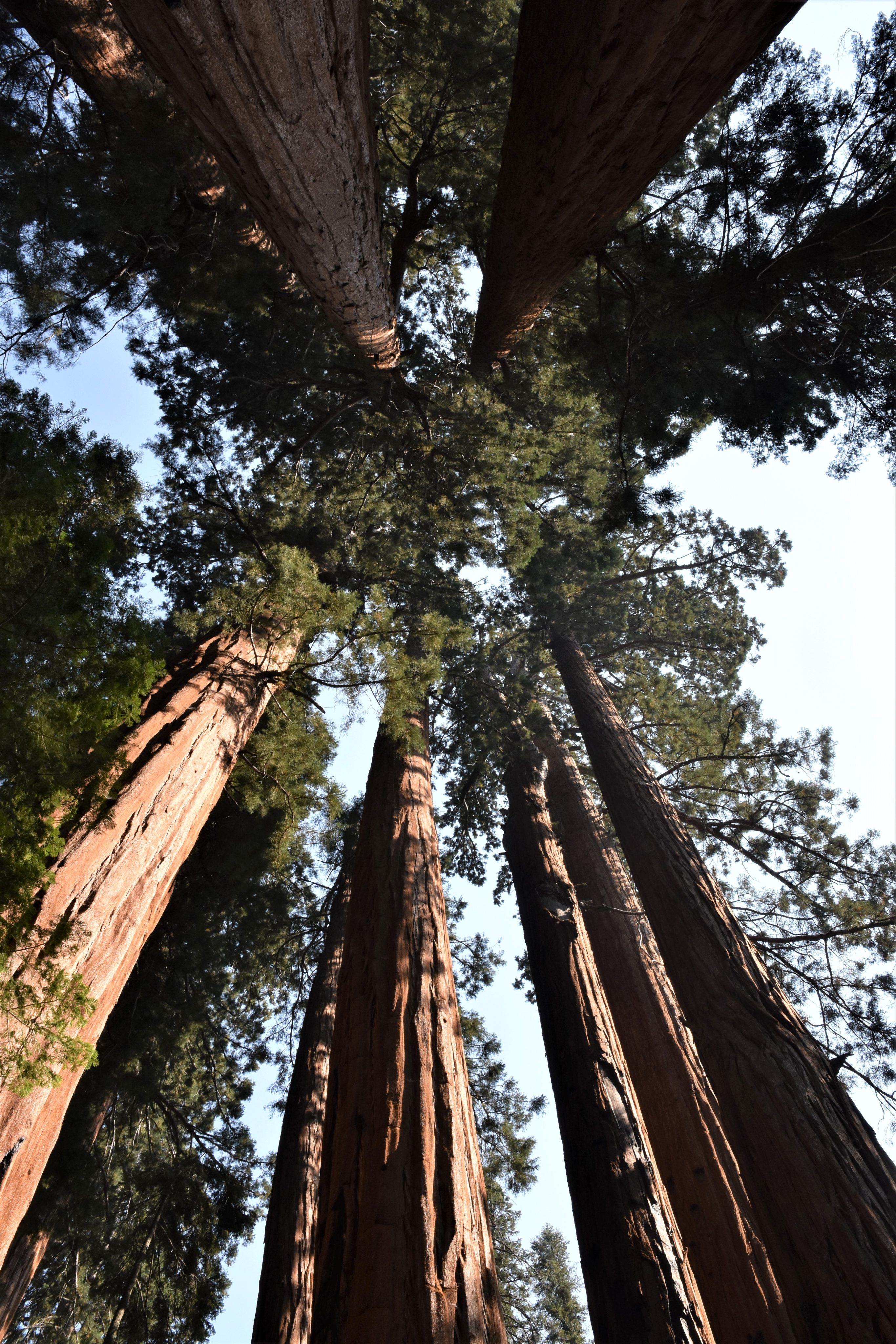
I awoke in the morning from my bivy sarcophagus to a new decade. In my head, I heard the voice from Google Apps say, “Arrived,” having dumped me in the middle of existential nowhere. A big part of the trip is over. It was what it was, it is what it is, and it will be what it will be. That’s the wisdom I’ve accrued over the years. Not having much shit on my shelf, I figure it best to go talk to the 3000-year-old Sequoia trees to find out what their wisdom is. After all, they’ve survived millennia of fires and fungi (but they do seem to be at the mercy of men and climate).
The campground is only fifteen miles from Sequoia National Park as the crow flies but an hour-and-a-half to get to as the car drives down circuitous and curvy roads. With another half-hour delay added to the ride for road maintenance, I gave up on my ambitions to hike deeper into the backcountry. There are always plenty of trees on the Big Trees trail to visit. General Sherman was way too busy showing off his massive girth to the hordes to have much of a conversation. Hordes was his word. He pointed out to me that its the same word I use for mosquitos.
I found an ancient that wasn’t so preoccupied. This is what it said to me, “I put out hundreds of seeds per cone and thousands of cones per year. Conservatively, over the course of my two thousand years of life, I might produce 200*5000*2000 or more than two billion seeds. I only need one success in two billion to be successful.”
F**king optimist. If I were 3000 years old, I’d be an optimist too. But they are resplendent and grandiose and flamboyant and Stephen King is turned off for a couple of days until I get back on the highway. So thinking with my cup half full, I agreed with his Majestic-ness. But then re-thinking with my cup half empty, it means there are two billion less one failures. So big trees suffer from confirmation bias even after all these years they have had to get their shit together. When I confronted them, they ignored my protestations and insights. The big trees spoke of resilience and perseverance as they looked down on me. I didn’t hear what the two billion less one missing trees had to say. Probably, the same thing I had to say. “Humph.”
Enough talking to the trees, I had to race back to the campground to greet Phil. Fortuitously, I saw him on the Big Trees trail hiding under an Illini baseball cap and behind a bandit’s mask. I was within two feet of him before I recognized that twinkle in his eye that makes him him. Two life long friends of over fifty years could have sailed past each other on the trail without a glimmer of recognition just like that. Easy come, easy go? It was a fortunate encounter. I didn’t have to rush back and he didn’t have to get lost in the middle of the night trying to locate the campsite. Well, maybe he has better luck with his maps.
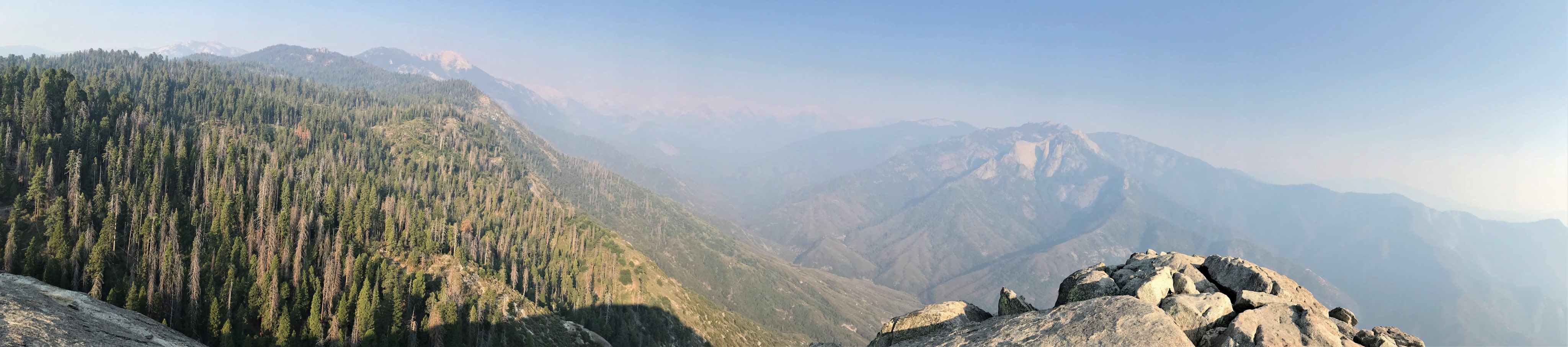
Phil and I headed to Moro rock. Despite the haziness of the smoke-filled air and the ominous presence of ravens, the steep climb thinly protected by a knee-high rock wall from a drop of hundreds of feet and a view of distant mountains across a deep valley was thrilling and awe-inspiring. A thick haze obscured our view to the west. After our summit and viewing, we trekked back to the campsite under a pink and red and purple sunset stopping briefly to watch a flock of turkeys crossing the road before rejoining Chris and Hetal for a birthday celebration. Celebration is kind of a strong word for a gathering of four and an event that I would have strongly preferred to keep as a target in the sight rather than a fading memory in the rearview mirror. On the other hand, there are two billion less one seeds telling me to f**k off. They never made it this far, relatively speaking.
Back at the campsite, we all enjoyed Phil’s beers, checked out the conjunction of Jupiter and Saturn, talked about COVID and politics and retirement and travel and a few other things I probably needed to shut up about already. I scored three sci-fis from Neal Stephenson from Hetal and Chris and a six-pack of Stone from Phil. I never got around to playing “Time Waits for No One” on the guitar. That is how you turn sixty. It was what it was, it is what it is, and it will be what it will be. I heard a bunch of trees groan in the darkness at the thought.
Enough of the moroseness of a happy birthday. Nothing to lift your spirits like the resplendence of a spectacular canyon. Parting ways with Hetal and Chris, Phil and I packed and hit the road for the Mist Falls hike. Kings didn’t disappoint. It was very Grand Canyonish, in fact, even deeper at its deepest point, with the advantage that you can drive down into it. It’s a long slow ride that makes a lot more sense if you camp down there over nights to spend more time participating in the wilderness than viewing it from behind a wheel. The campgrounds we drove past were closed and the road was empty.
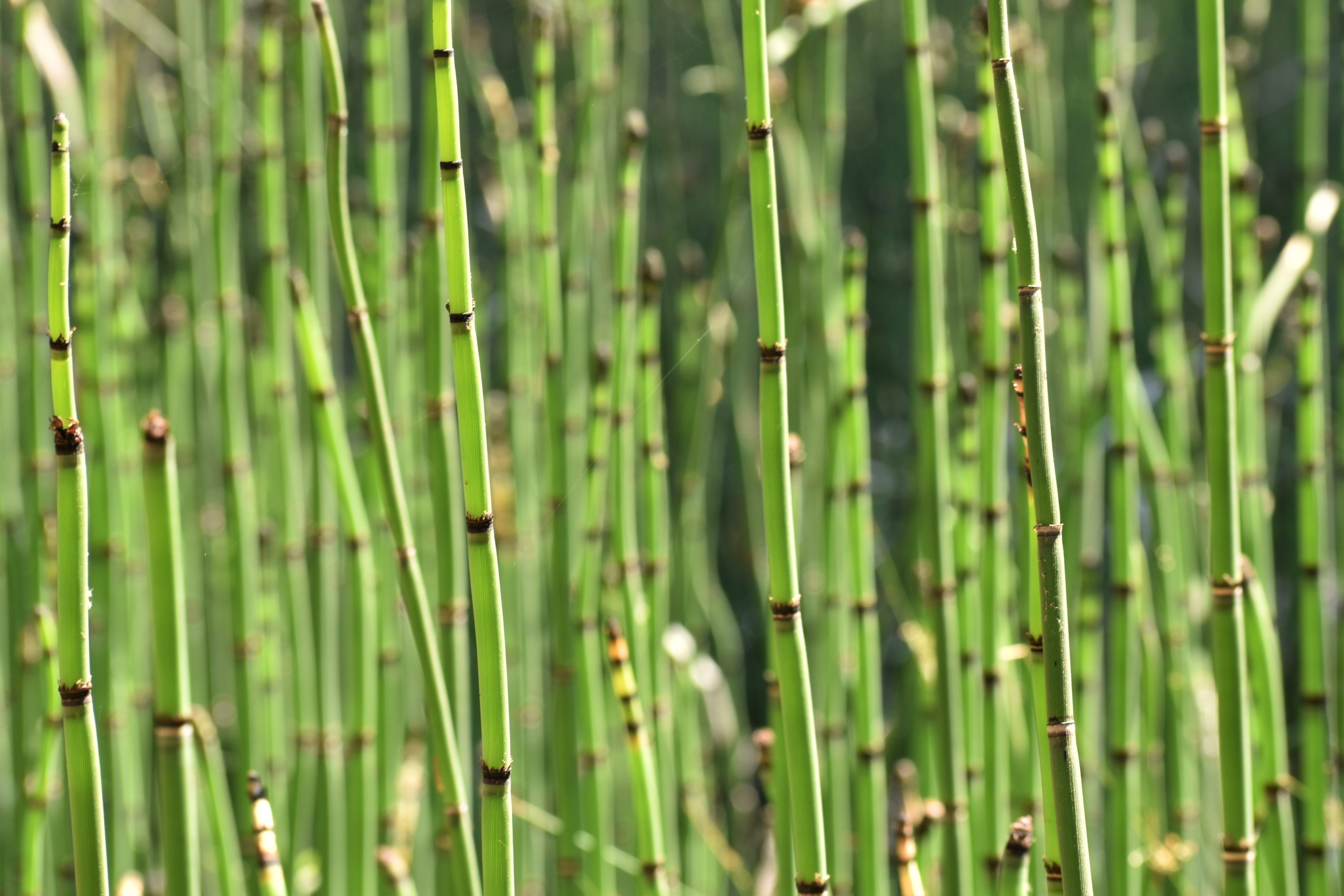
At the end-of-the-road trailhead to Mist Falls, we caught up to other cars and hikers but nothing even remotely overwhelming for a national park on a perfect summer day. The first two miles of the Mist trail was flat following the South Fork of the Kings River. The walls and peaks towered overhead in the haze from far-off fires in the Valley. A mule train led by two park rangers passed us on a hot and dusty section of the trail loaded with metallic canisters of unknown cargo. After a mile or so, the open trail ducked under a riparian forest to a prehistoric undergrowth of horsetails and ferns. At the two-mile marker, the trail veered north turning into a gentle climb as it followed the contour of the canyon alongside the river.
We stopped so I could take pictures of the stream. I managed to forget my poles, walking for about a tenth of a mile before realizing my mistake. After I retrieved the damn poles, I contemplated the efficacy of my brain efficiency. It’s just a matter of time before I forget something critical like turning off a stove burner for a night or forgetting to zip up my fly after a bathroom break during an important meeting at work. But instead of getting angry at frustrating times like this, I remembered an extremely useful piece of advice, “ask yourself if what you are doing is helping the situation or not.” I heard it on a TED talk on resilience. Anger and or self-pity don’t help the situation. I know, I’ve tried. That one phrase has so far kept me out of any up and coming Stephen King novels.
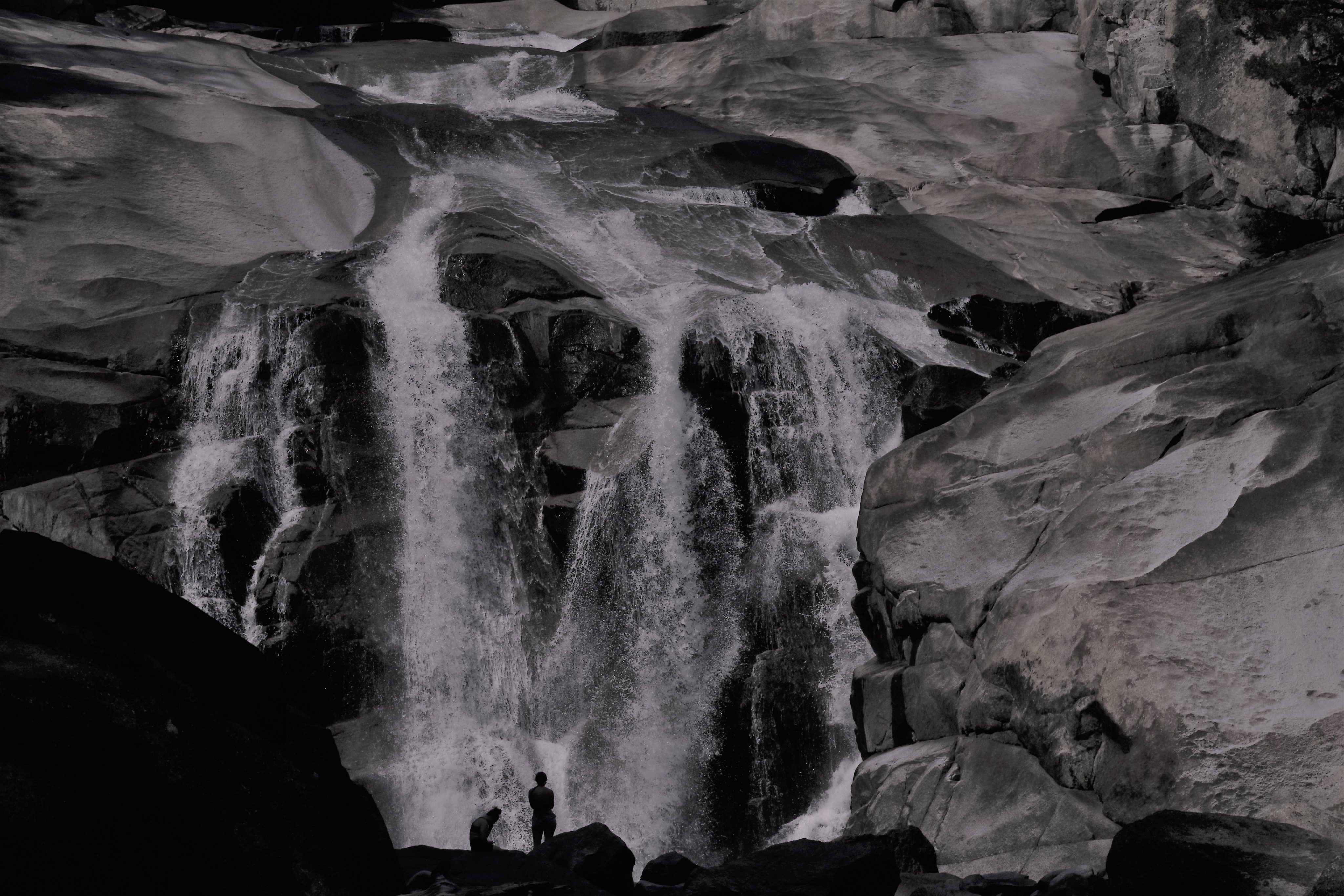
Mist Falls
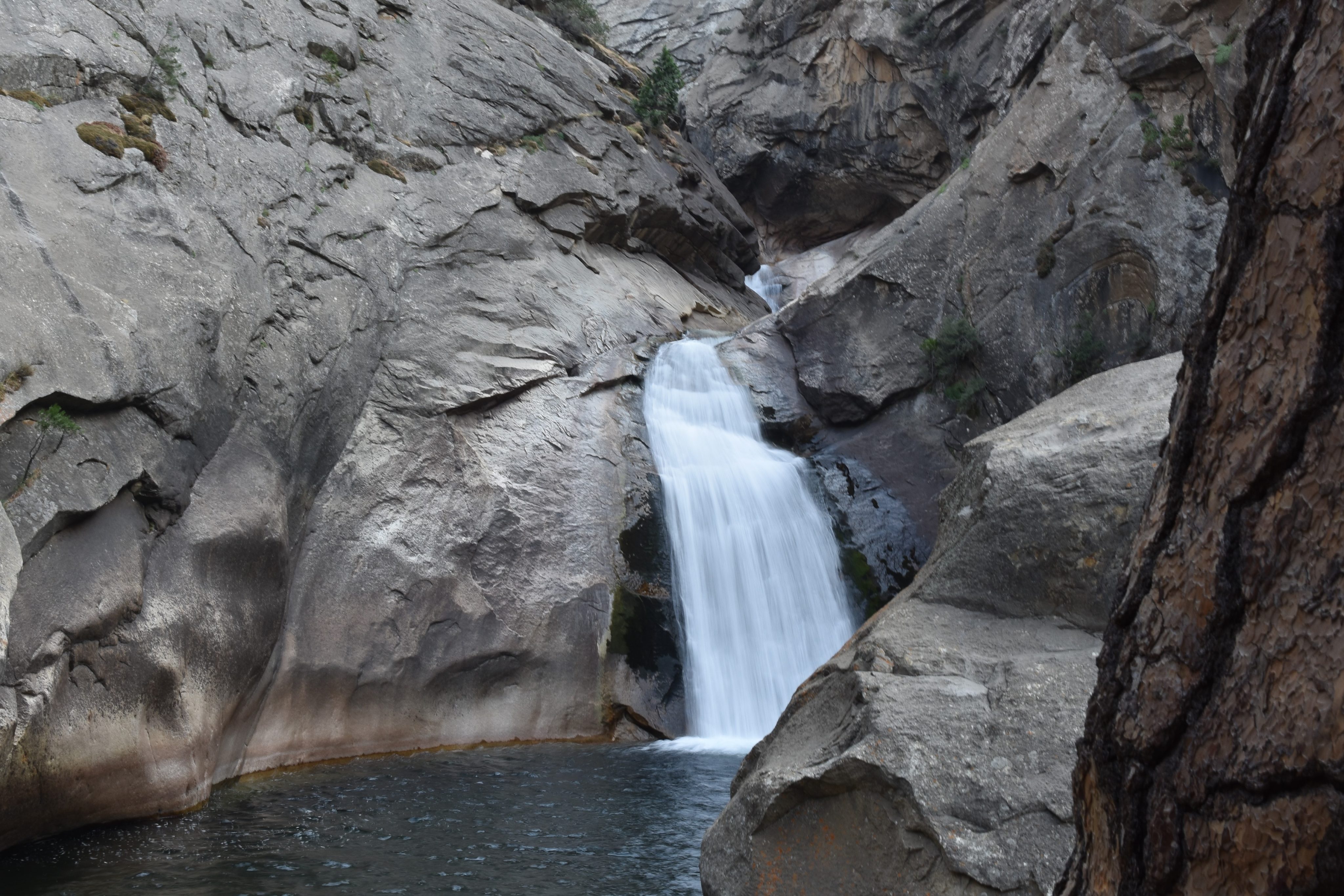
A few stretches of the trail are steep enough to warrant a granite staircase. We passed cascades we thought might be the falls. A catch-and-release fisherman regaled us of his multi-species trout catches of the day and told us the falls were just up the trail about a half-mile. A sign marked the spot of the actual falls but once you see the falls, you won’t mistake them for anything else.
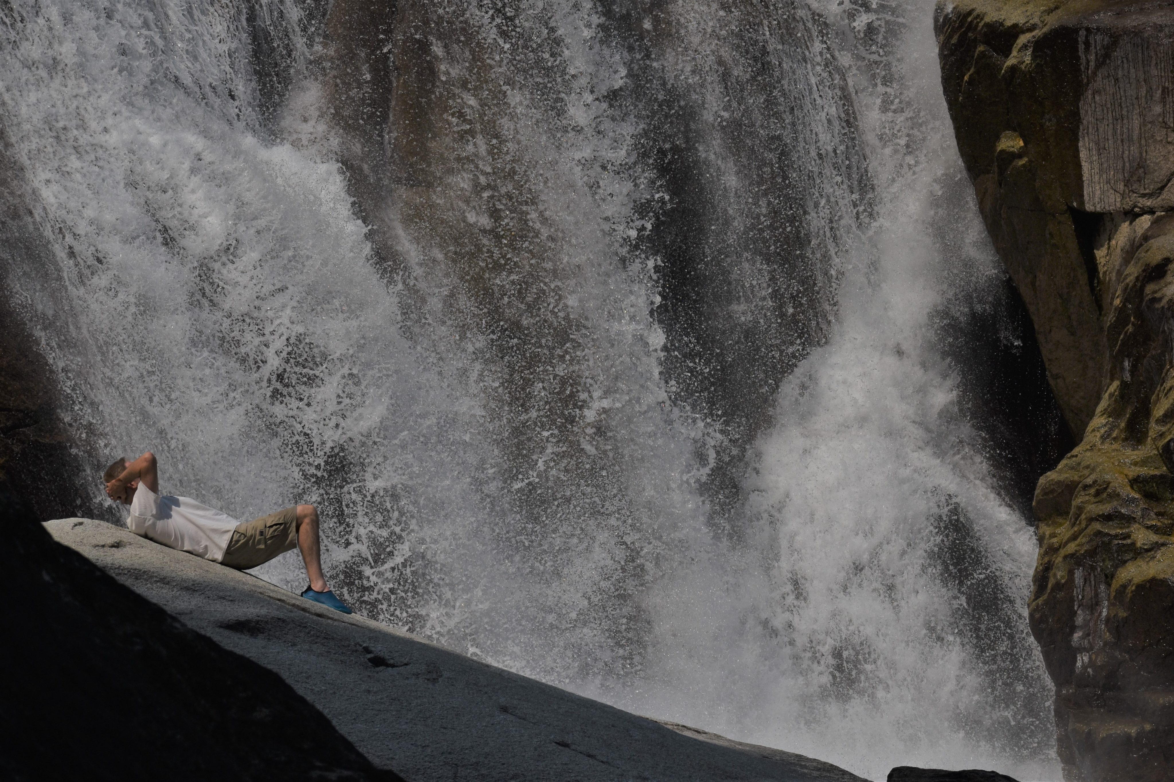
The falls were extremely photogenic with a peak off to one side, trees on the rim near the top, and a rock protruding from the bottom pool that allows people to stand right in front of the falls almost as if in them. I usually try to take pics without people but I think, in this case, the people add a sense of scale and contrast. Phil took full advantage of the pool at the base of the falls with a swim in the cool waters. We found Phil’s wheelhouse.
After a hundred photos, a quick jump in the pool, and a modest lunch, we headed back. Most of my hikes these days are solo filled with finding interesting things and composing pics in my mind but this one breezes by with Phil’s company.
On the way out of Kings, we made a quick stop at the Roaring River Waterfalls. It is just off the road on a paved trail and another photo op. A little further down the road, we stopped in Visalia for dinner. Surprisingly, Visalia had a pleasant restaurant row with outdoor seating. We ate at Corby’s Rock N Roll Heroes. Don’t be fooled, it isn’t it a record store, it’s actually a restaurant that plays great classic rock’n’roll with a very pleasant young server who surprisingly does a lot of day hiking on her own in Kings.
Stephen King rejoined me for the ride home to San Diego but he’s not such pleasant company on this leg of the trip. In 1999, he ended up getting run over by a callous man trying to stop his Rottweiler from digging into his beer supply instead of paying attention to the road. If not for the quick response and impeccable treatment by the first-responder, Stephen assured me that he would have died. As it was, he had a crushed leg that looked more a bag of marbles than a bone, a punctured lung, broken ribs, and bent frames on his eyeglasses.
Stephen told me that the inspiration credited to drugs and alcohol is a myth. He should know, he was an addict. I read somewhere that after decades of abstinence, he fell off the wagon again. I don’t know if he has once again kicked the habit. I do know he has published over 60 books. Two roads to hell and one to redemption.
He tells me I have to write, write, and write, and then write some more. He also tells me I have to read, read, and read, and then read some more. Damn it. I have a job.
Stephen finally shut up and I finally made it home. I watched the grittiness of the backcountry wash off me in black streaks swirling down the shower drain.
So one symbolic milestone came and went. I continued to doubt the efficacy of my efficiency and I learned that the road to hell is paved with platitudes, adverbs, and gophers.
I imagined myself plotting out the road to hell in Google maps. Same road as Stephen King’s and Hannah Arendt’s. And herds of gophers. I followed its direction. I got stuck in purgatory. I paved the road with colorful phrases like, “Where in the hell are you taking me?” No adverbs were necessary. With any luck, I permanently lose myself at the end-of-the-road on the Kings Canyon Scenic Byway.
I heard my internal map app voice speaking in my head, “Return to the route. Return to the route. Return to the route.” I’m sixty years old and I dumped me in the middle of nowhere. What route? What map?
I look at my older self in the mirror and say, “Now what?” He snarls his lips in disgust and disdain, stares back from inside the mirror, and says, “You live with it.”
Someone asked me how my day was and I said “Bobcat!” Okay, I admit I’ve totally lost my ability to interact in any ordinary way. I blame COVID. I’ve been in isolation for the last six months.
I’ve been hiking in this area for the last 36 years and this is my first bobcat siting. It darted across my path in Kit Carson Park in the middle of the day. Unmistakable. Too big to be a cat. Too fleeting to snap a picture. I know bobcats aren’t rare in these parts, but that’s not the point. The point is that it was a cool moment for me in a time when cool moments are hard to come by.
It’s still summer and it’s still hot. The best place to be is on the beach and the closest, wildest (for wildlife, not parties) beach for me is Torrey Pines. On this particular hike from street parking in Del Mar south to the north end of Black’s beach, the tide is rather low. I can see the crescent moon in the sky so I know it is not quite the lowest tide but pretty low given the expanse of beach to walk on. I do most of the hike shoeless and in ankle-deep water. I read the water temperature is up from the low 60’s of my foggy trip to the upper 70’s of this heatwave. Wading and swimming, I don’t have any trouble believing the report.
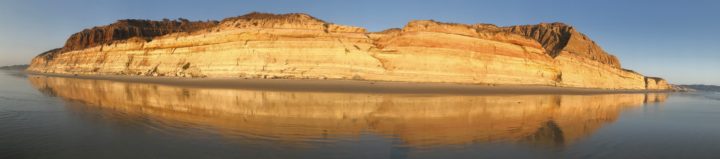
I bring my camera because the ocean and sunset never get old, at least in my humble opinion. With the tide low and golden hour light, I get some lovely shots of the cliffs with their reflection in the surf. The golden glow of the sun brings out the pinks, reds, yellows, browns, and oranges of the cliffs and in the reflections. I tried catching mirror images of the cliffs and shooting straight into the sand for more abstract shots. The play of light and water and color is fantastic facing back towards the cliff in the shallow surf, but I think I need to improve my camera work as the photos are little on the dark side. I think I will make a point of getting on the beach at Torrey Pine’s when the low tide is at sunset on a perfect day until I perfect my craft.
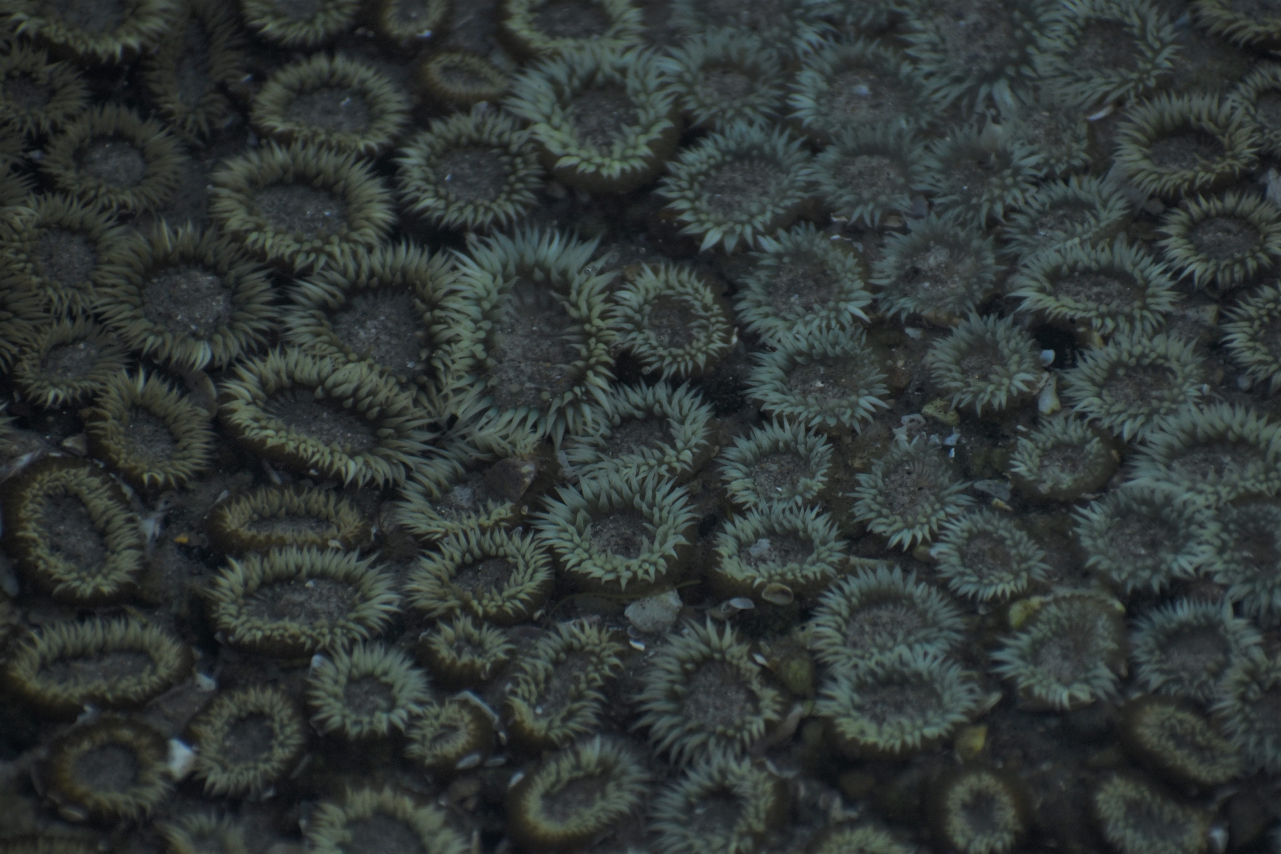
It is not too often I can walk on the ocean side of flat rock without fear of water-damaging camera equipment or getting smashed up against the rocks. The last hike, I couldn’t even get on top of Flat Rock from the beachside approach because of the high tide. This time, I casually walked around flat rock no problem. I took pictures of the matted anemones on its top side and barnacles on its underside. I can see fish working the surf and lots of fishermen trying to work the fish. A little boy charged with filling the bait well with sand crabs feels compelled to give me a close up of one.
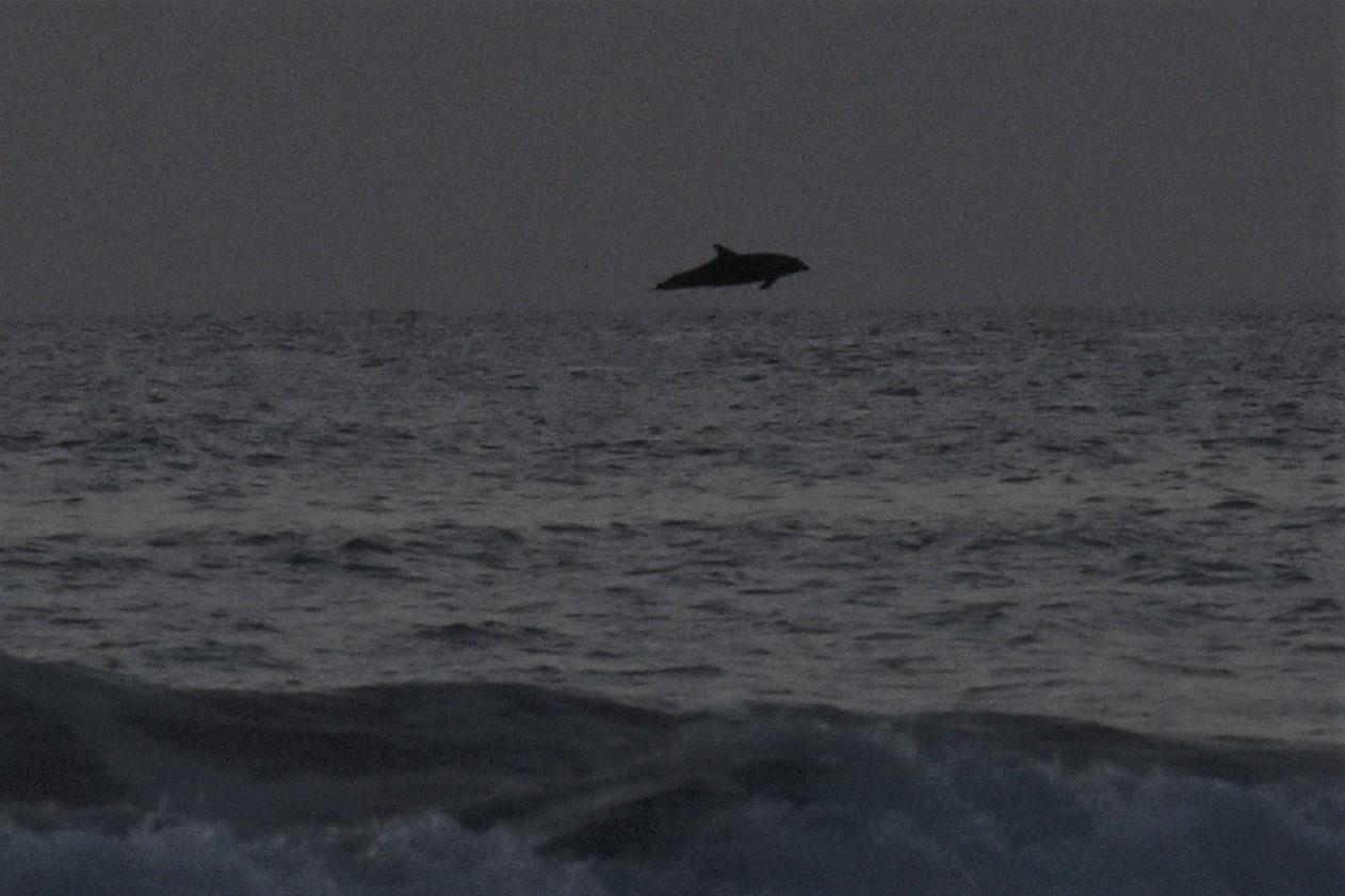
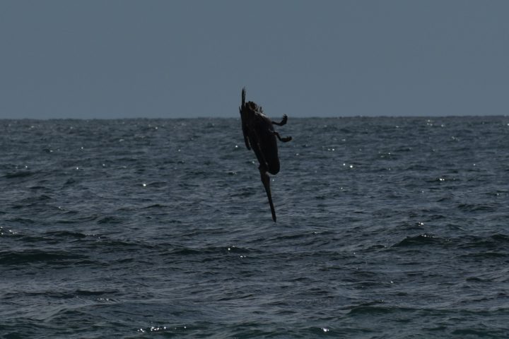
Airborne Dolphin
Given the heat and the perfect weather, the beach seems relatively empty. Maybe its because the low tide has people spread out so much but the leg from the south parking lot to Flat Rock is sparse enough that I take plenty of people-less shots. Zoom in on the pan and look for people if you don’t believe me. The stretch from Flat Rock to North Black’s Beach is even more deserted. Black’s Beach itself looks as popular as ever but that is a story for a different venue.
I time the hike just about perfect to end up back at river’s mouth at sunset. A paddleboarder helped my cause by surfing back and forth in front of the setting sun making for some nice silhouettes in the orange glow. And while I was doing that, I saw dolphins skying out of the water in the distance. My perspective may be off because of the distance but those dolphins looked like they were getting serious hang time. Enough for me to look out, find them, and snap. It looked surreal to see these creatures leaping out of the ocean into the sky. If they had been in the line of sight of the sunset for a dolphin silhouette against a deep orange sun, I might have ** with excitement. Insert your own inappropriate metaphor there.
A flourish of trumpets. Not a grand entrance, think a quest, like King Arthur from the most Holy Grail of Monty Python. The holy grail in this case is the green flash. It’s one of those things you can wait your whole life for and never see, like Mercury or a full solar eclipse.
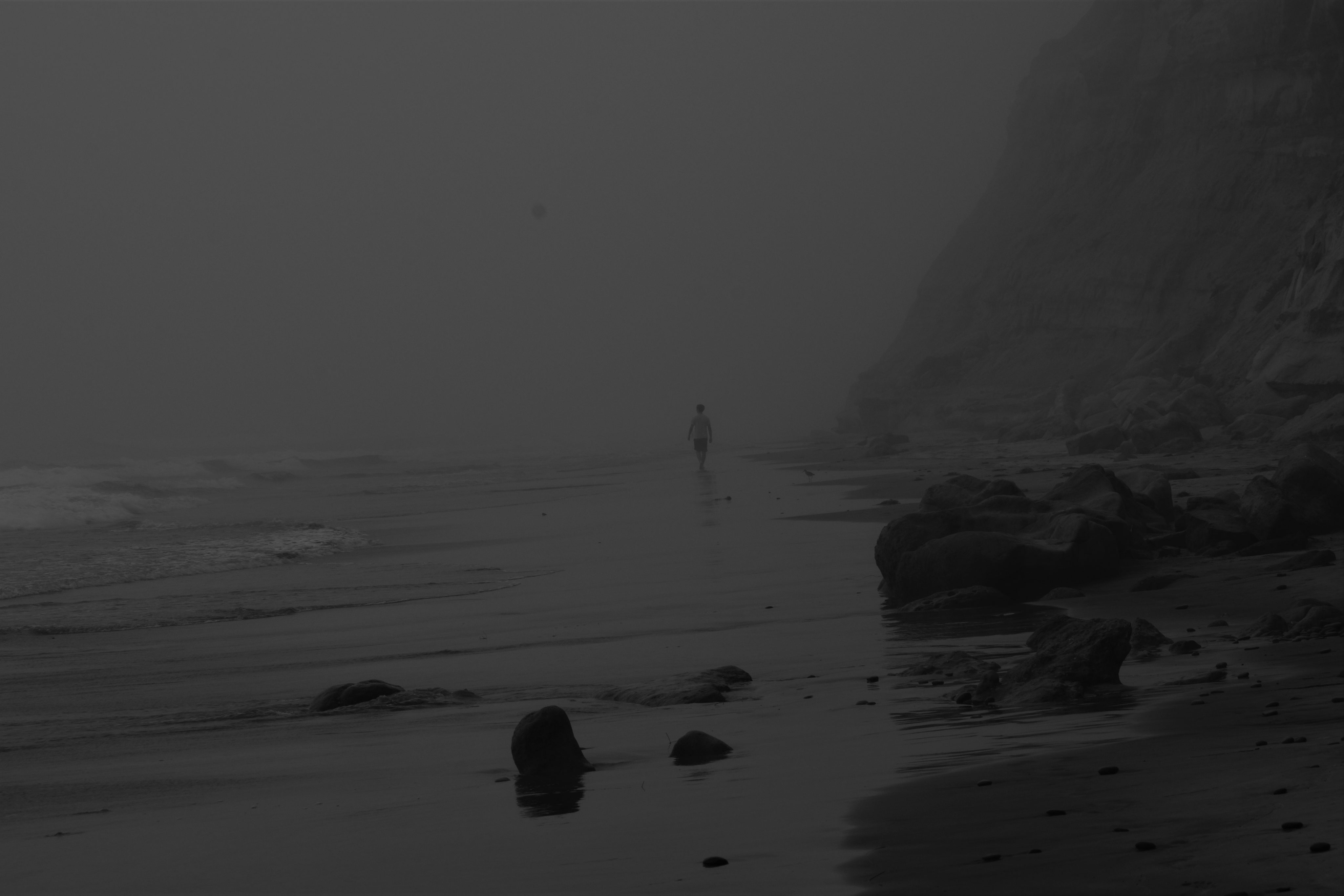
The Tale of the Fog.
Disappearing
It’s summer. It’s hot. There is not a cloud in the sky. If I’m going to hike, I’m going to hike on the beach. I figure if I time it right, I might be able to catch a sunset. So I pick up my son and drive over to Torrey Pines. Instead of finding clear skies and a sunset, we find fog and high tide. The fog is so thick it is night time in the day. Instead of pelican’s plunging into the ocean for fish, I see phantoms in the shadows dive-bombing into the unknown. Creepy crustaceans with big black eyes coat the sandy walls of the cliffs, which we are forced up against as the waves of the high tide lap at our legs. The murky fog is a minimalist dream, if only for some more light.
A man passes asking me if I know if it is the high tide. It most definitely is high tide. But he is heading south into the rocks and cliffs. He wants to know if it is THE high tide. I don’t know. I would have thought that high tide occurs when the moon is straight overhead or at the exact opposite side, but it is not so, this is only true in a perfect spherical world, one of all water. Alas, the tides know no table and the world is not perfect. Landmasses and other effects determine the exact times. THE high tide is still to come in about an hour but three hours ahead of midnight about the time I would expect the full moon to be straight overhead.
The Tale of the Mountain View
Fog Bank
I hiked up this rather steep trail before to a ridgeline from which I discovered you can see the Pacific Ocean in spots before. I thought it would be a great spot to catch a sunset, particularly if the sunset lines up with views to the Pacific. I made it a point to return.
So suffering from acute cabin fever on an off Friday from work, I decide about an hour before sunset to see if I can’t hike up the mountain and score a few pictures. Because of the steepness of the trail, the lack of anything remotely resembling traction on the bottom of my shoes, and dusty, slippery, grain-sized granite, I bring my hiking poles with. In my mind, I glide to the top like a cross-country skier with the intensity of an Olympic champion. In reality, I am fast enough to make it to the top with about fifteen minutes to spare before sunset.
I find a decent rock to take pics from, but I can see the huge cloudbank covering the coast dashing my dreams of the sun dropping into water and its yellow-orange tail following it over the horizon. I set up the iPhone for a timelapse setting of the sun, admire the deepening colors of the golden hour, and snap a few pictures. A fog bank and a sunset have their own charms.
On the trip back, in the blue hour, I say hi to a pretty girl walking a dog who admired my walking poles, watch bats dart across the trail, and follow an owl as it glides silently in front of me. No pictures of any of them. Not sure how I would do that anyway. Skittish girls, flitting bats, and gliding owls, never listen to my requests to stay still long enough to take a picture in the dark.
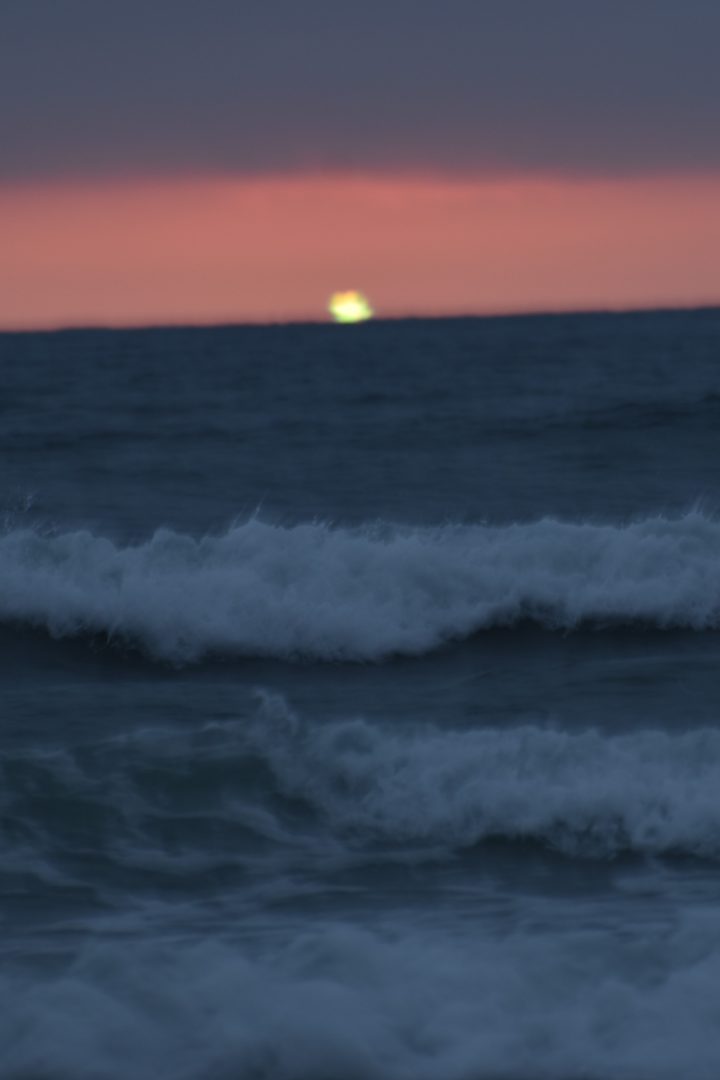
So, what does that say about me and the times that the highlight of my day is escaping the confines of my house for a sunset on a Friday evening? When I later checked the pics, I discovered a hint of green in the sliver of the sun as it disappeared into the fog bank. The green flash? Okay, not quite but definitely caught some green. An image of the Holy Grail hovering over a castle in the distance.
The Tale of the Most Holy Grail
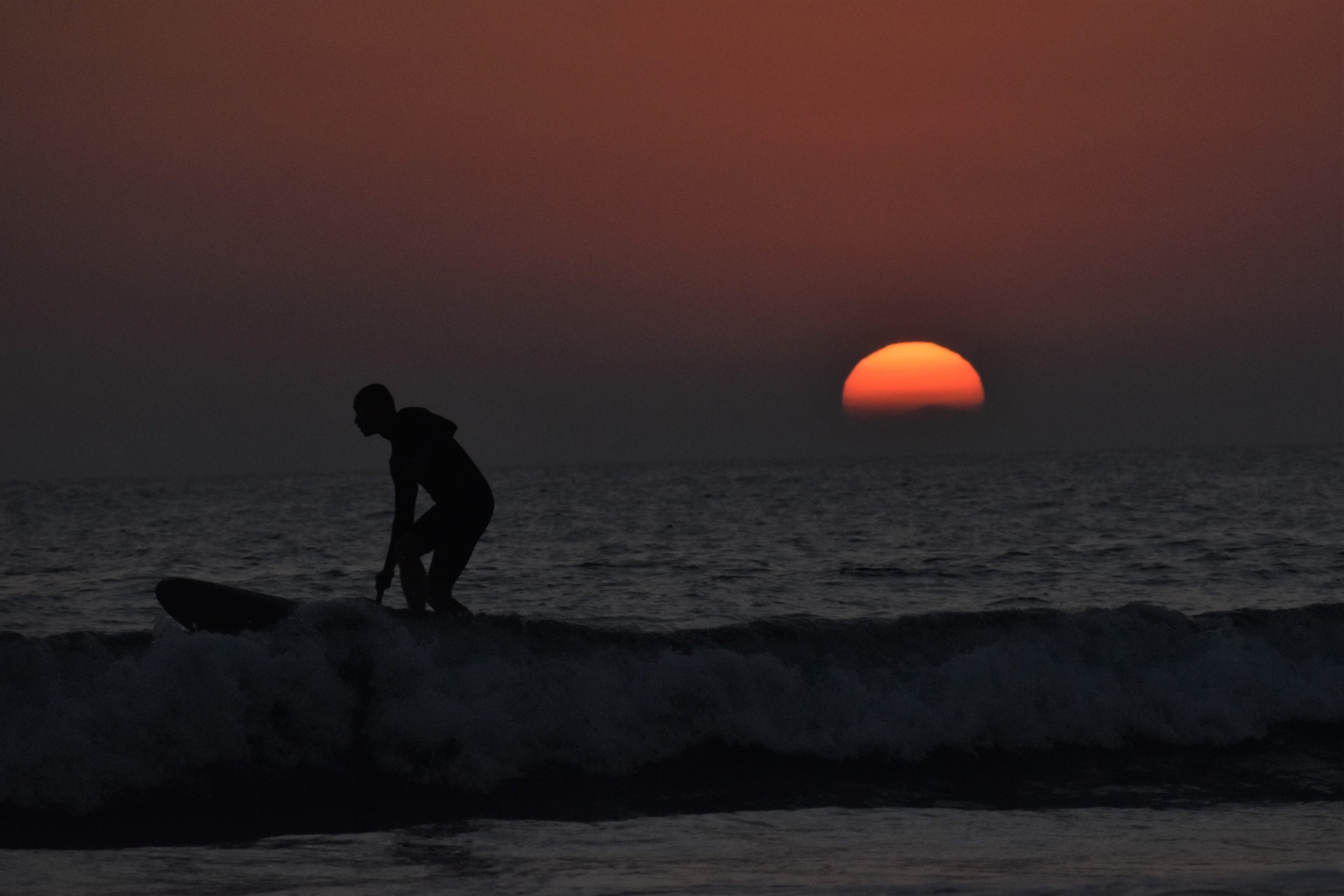
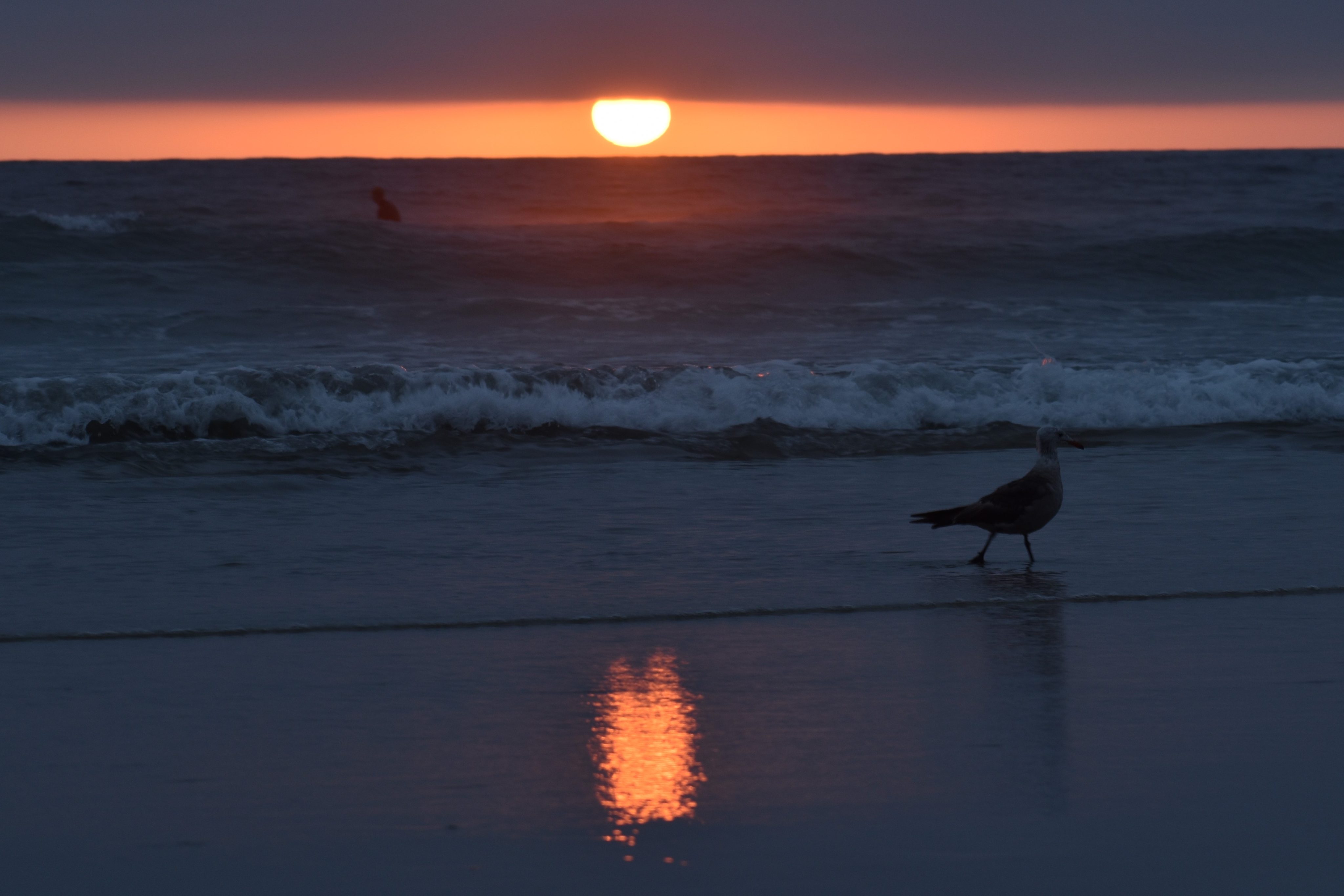
After a five-mile hike up and down the beach from Torrey Pines to Dog Beach in Del Mar, the sun drops out from behind a purple cloud curtain, not quite the eye of god poking through an opening in the clouds, but nevertheless, an impressive game of peekaboo. As the sun reasserts itself, surfers ply their trade in the foreground in a mild surf, fishermen troll the shallow waters for surf fish, and shorebirds plunder the plentitude of sand crabs.
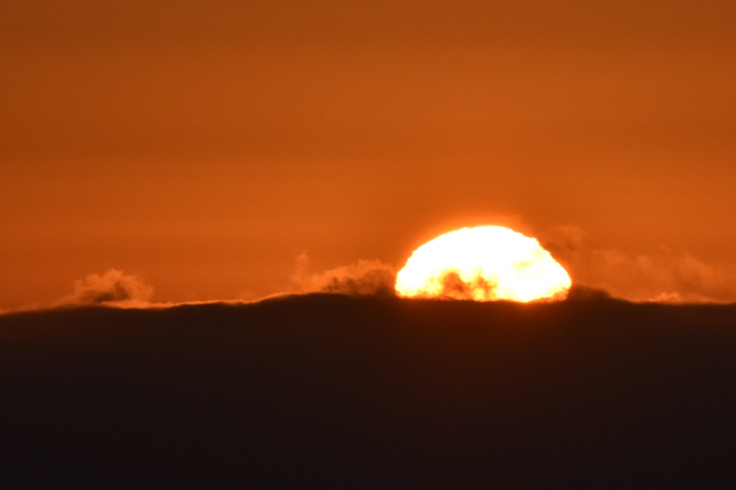
No sooner then the sun pops out from behind one curtain it begins dropping behind another. The red-orange ball of fusion morphs from a full sphere to the outlines of an exploding earthly fusion bomb to a blip. The blip doesn’t disappear over the horizon, it turns green, fades, and disappears into a point just above the horizon.
The green flash. The most Holy Grail of sunsets. This is the real deal. A life long quest satisfied. I see it. I have a witness. I have a picture. It really exists.
I admit it is not a great picture. But that is how it goes with mythological creatures. Ask the Bigfoot photographer. Ask the Loch Ness monster photographer.
The quest is not at an end, only a beginning, now that I know it is real. You never know. I know I can see it again even if it takes another sixty years. I will be looking for it or die trying. Besides, what else am I going to do on a Friday night?
With temperatures hitting the low nineties in Escondido, I decided to take a cool walk on the beach toward Flat Rock. Torrey Pines State Park remains closed as of July 18th but the parking lot is open and the lifeguards are manning the towers. The weather was perfect, just right air temp for hiking barefoot in the shallow surf, the skies clear, and the water warm enough for a comfortable swim though I don’t have an exact measurement to give you.
Looking North at Torrey Pines State Beach
I was shocked at the crowd, or rather lack of it. See https://www.thetembo.com/clip/2020/05/17/1102/ for my earlier experience. On the north side of the river, there was a decent crowd with people practicing some sketchy social distancing. But past the first lifeguard tower on the south side, the distance grew to about a hundred feet of social distance, and once past the last lifeguard tower, the beach was as empty as I have seen it on a summer day. Not much of a surf so no boarders to be seen.
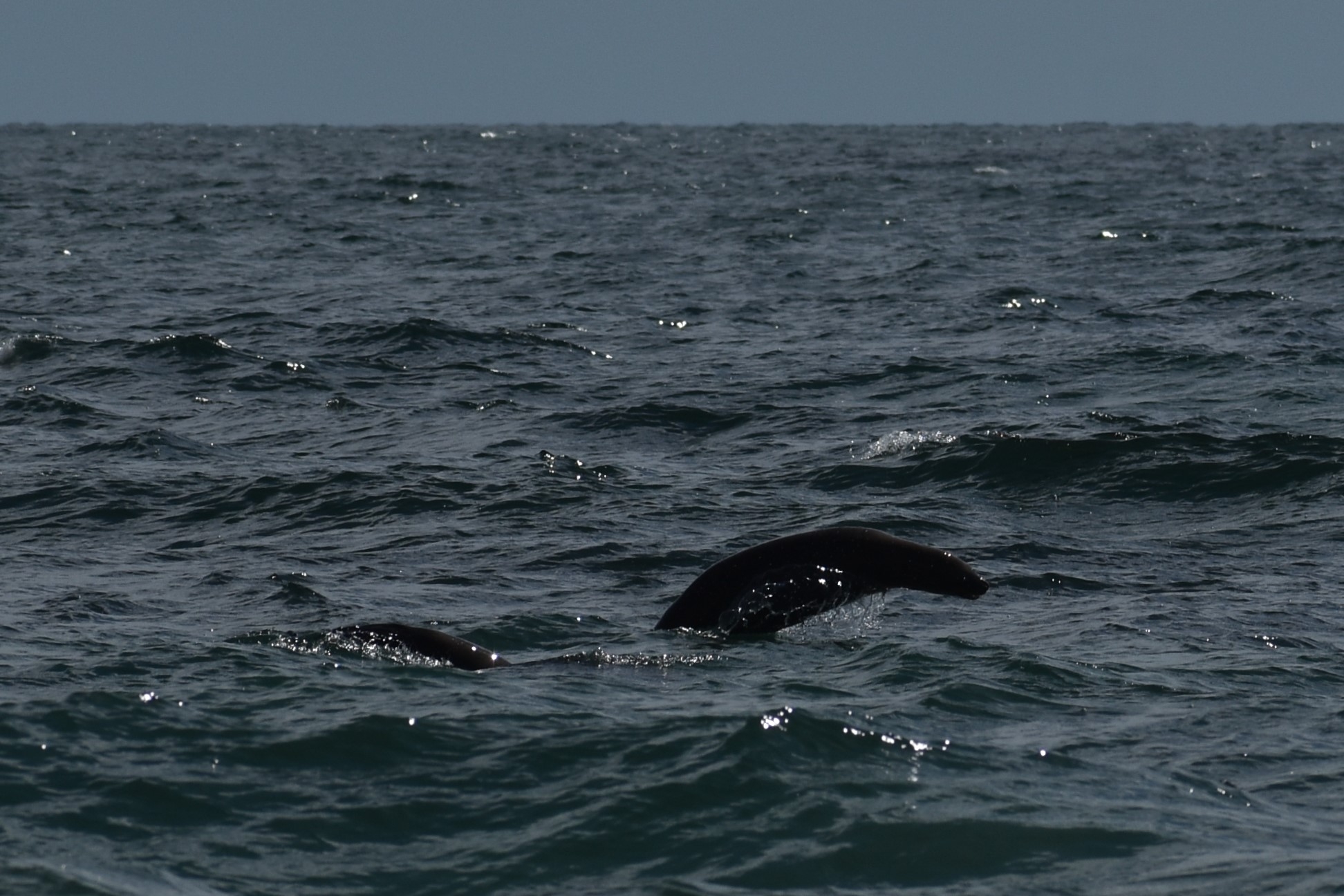
Porpoising Seals
The beach is none the worse for lack of a crowd. I saw several surf-feeding corbinas, small stingrays, and sand sharks lurking in the shallows. I watched a corbina catch by a fisherman working the shore with five poles. The shorebirds seem happy (what you can’t read the facial expressions of a shorebird?) Seagulls never do mind people, but some of the other birds are a little more skittish. An osprey patrolled overhead from his nest in the honeycomb cliff tops. Brown Pelicans dive-bombed for fish. I didn’t quite capture a water-breaking impact but nevertheless, I think dive-bombing makes for a dramatic picture. I was lucky enough to snap a small seal porpoising into the air and now that I’ve seen it, I wonder why the porpoises don’t seal?
The activities down on Black’s Beach are interesting as always but I won’t comment any further on that other than to report that naked social distancing is a real thing. I’m sure my like count would jump from my four likes to substantially more if I captured and shared some of those photo-ops on social media. I’m equally as sure my providers might register a few short and final dislikes as well.
Since my abortive first backpack to the Ansel Adams wilderness in early June, attempts are being made to reopen the backcountry, the state, and the country. A month ago, the 3.5-mile road to the trailhead was closed and its parking lot empty. This time, arriving at 7 on Thursday morning in July, we barely scored parking spots for our cars at the packed Agnes Meadows trailhead parking lot.
I for one am glad I didn’t have to hike the 1000 foot elevation gain over the 3.5-mile at 9000-foot elevation road a second time but this time with my forty-pound pack. I had renewed appreciation for the June hike up the road as I was driving my car trying to squeeze by others on the narrow winding street. Since I only day hiked the trail on the first outing leaving my friends to their backpacking adventure, I trekked up the empty road by myself on the way out stopping in the middle of the pavement at my leisure to take pictures of wildflowers, wildlife, and scenery or simply just catch my breath. Not one car or bus.
This time, on the drive out, the line to get on the road at the pay booth entrance near Minaret Overlook was a mile long. I do not think I exaggerate the distance. I can’t blame anyone for wanting to get outside in the wilderness on a beautiful 4th of July day, but that long of a wait and only to discover that you might not be able to park anyway would just suck the joy out of the experience.
On the first trip, I was able to get a hotel room, but restaurants only offered carryout or drive-through service. Bars and basically anything with a hint of a gathering was closed. This time, the hotel didn’t offer breakfast or coffee and the amenities were handed to me in a plastic bag when I checked in. The restaurants and even bars are open again under the weird rule that I’m only mildly comfortable with, you don’t have to wear a mask at your table but you have to wear it everywhere else. Of course, it’s the same everywhere in California. Outside is better than inside. Open is better closed. Distance is better than closeness. If you have to be indoors, good air circulation preferably with filtering would seem to be the option of last resort. It seems oddly weird to watch people sit indoors with a bunch of other people in the midst of the pandemic while hikers pull their masks up over their noses as you pass on the trail.
Ewok
The forecast for this trip was abundant sunshine with overnight lows in the upper 30s and lower 40s. So, sans the threat of daytime rain and overnight temperatures in the teens, I ventured into the wilderness with my forty-pound backpack, which is eight pounds more than the recommended maximum of 20% of body weight. I could have gone a little bit lighter on the clothes but not much. When I packed for this trip, I ditched my rain jacket for an emergency poncho knowing the forecast for intense sunlight, so I saved weight there. I don’t own a lightweight jacket so I compensated by carrying a couple of long-sleeve shirts. I could possibly lose a little weight there. I definitely should have left the crampons behind since we never had to negotiate any ice packs. I took two camera bodies instead of one so I didn’t have to change lenses every time I shifted from a closeup to a scenery shot. The camera body is light, the wide-angle and telephoto lenses are heavy. I took a lightweight fold-out chair which was really nice to have but not necessary. Camera equipment is heavy but when your mission is to take the best possible pictures, good equipment is not something you want to leave behind. I should have carried a first-aid kit, but didn’t. I really liked having my life straw, a water bottle with a built-in filter that I used to fill up at a stream whenever I needed to instead of stopping to put together a filtration unit. If there is a next time, I will work harder to get the weight down.
The things that worry me the most are not the expected problems of high altitude and fatigue but the structural pains such as a sharp pain in the knee and excessive hip pain especially on the downhills under the straining weight of the pack. But all-in-all, this old body protested but did not crumble.
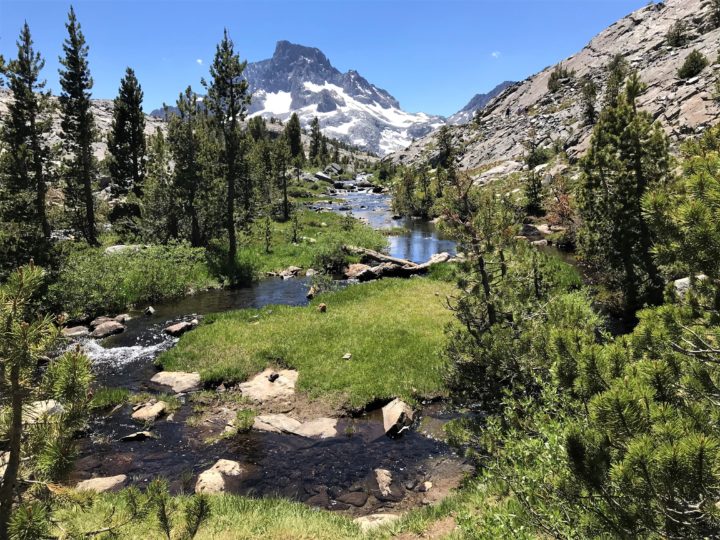
For the record, the trip was three days and two nights long. We hiked ten miles to Thousand Islands Lake on the Riverside Trail doing some back and forth once we arrived to pile on extra mileage. We hiked two-plus miles to Garnet lake reaching the highest elevation of 10,400 feet. Both lakes are at 9,800 feet in elevation. And then the seven-plus miles back to Agnes Meadows.
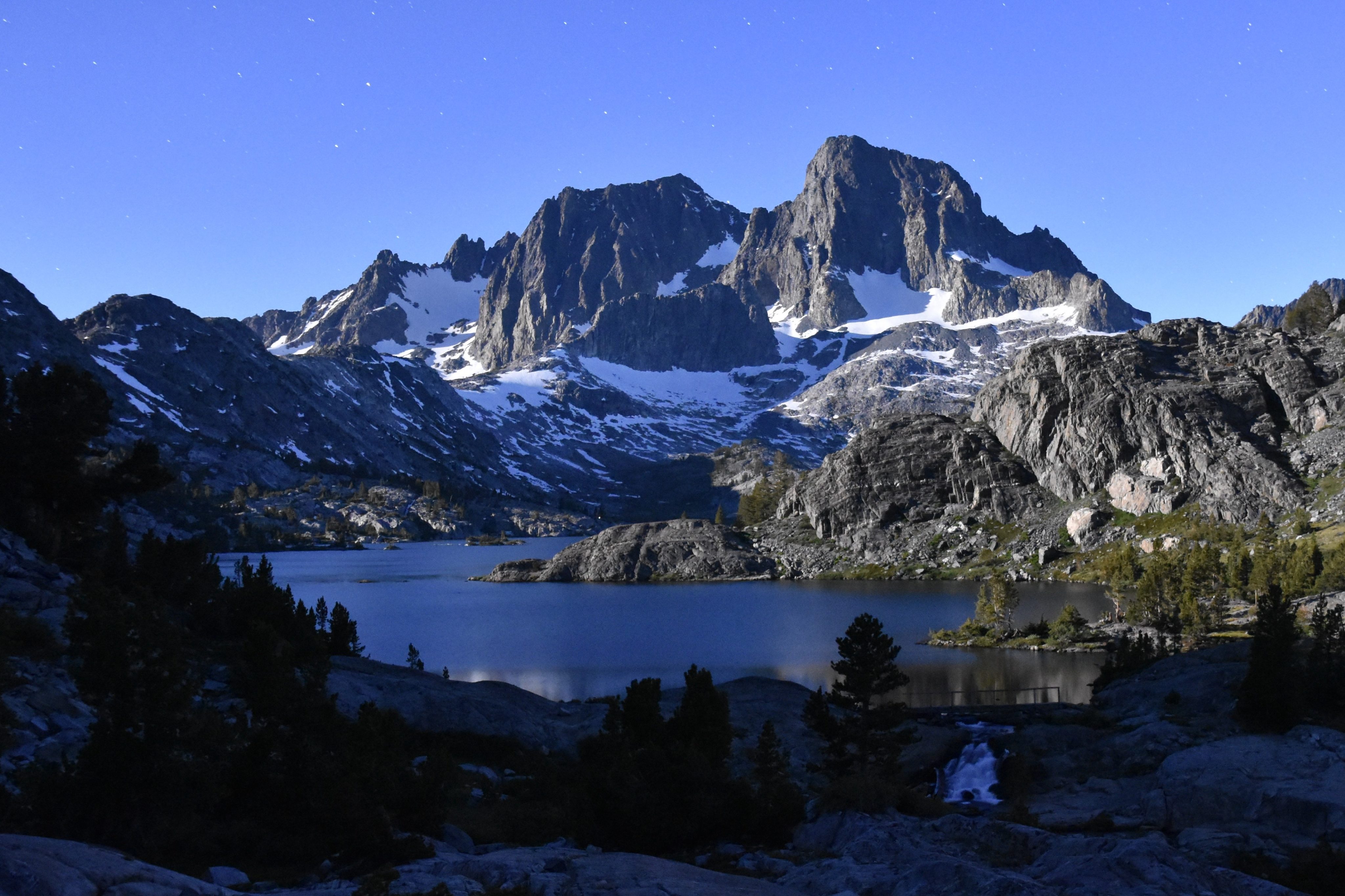
Garnet Lake under Full Moon
On the success of the mission from a photographic point of view, I will leave that to your judgment. We didn’t get any clouds, which as long as they don’t obscure the subject matter of interest, add significantly to the drama of the composition. We didn’t time the night pictures very well. If we had woken up at three-thirty instead of two-thirty, we might have had a full moon over the mountain and its reflection in the water. Then again, the incredible glow of the full moon presents all kinds of challenges for night photography. For one, it rules out capturing the Milky Way as a backdrop to the mountains. All-in-all, I’m very happy with my pics, at least until I see the other guys. The fun thing about traveling with a purpose, in this case attempting to take great photos of incredibly scenic backcountry, is that you end doing odd things that you wouldn’t otherwise do, like get up at two-thirty in the morning for shots of the night sky and then again at five to take pictures of the mountains in the sunrise. Or walking up and down the same shoreline over and over or climbing high up on the rocks looking for that perfect composition. It’s great traveling with experts because they have a great sense of composition and great command of the technology. If they allow it, I will share their links here.
GoldenStar
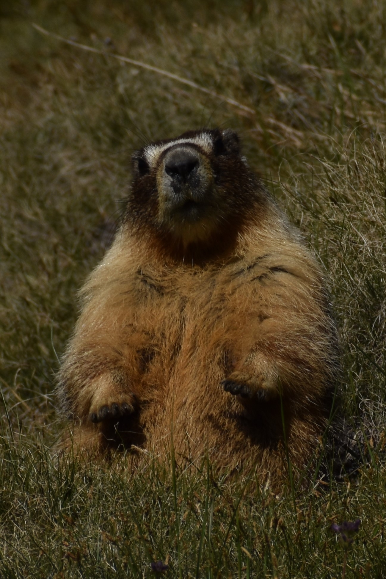
On the success of the mission from a nature point of view, I would claim a resounding victory. You can find beauty and intrigue in the large and the small and everything in between. Aside from the mosquitos, which can be a complete nightmare if you don’t bring repellent and even some mesh, the beauty of the water and the mountains is amazing and a picture can only begin to give you the feel of the immensity. The wildflowers are in full display. Mountain wildflowers tend to be smaller than their lower elevation equivalents. You have to look harder, but if you take the time to look, they are everywhere and of surprising variety. The insects are also everywhere too busy flitting from flower to flower and buzzing about doing whatever it is that they do. Be sure to check out the proboscis on that fly/bee insect in the photo. I was lucky enough to get a shot of one at work on the long narrow tubes of purplish flower. Regrettably, the one interesting mushroom I found growing under a pine tree, which resembled a hot-cross bun, didn’t turn out.
On the success of the mission from a spiritual point of view, perhaps the most important aspect of the trip, three days really isn’t long enough to truly disconnect but only to feel a vague uneasiness that those things, coffee, alcohol, and connection to people and news, aren’t there and to notice that your world goes on even inside your little nature bubble. Or is the bubble the other way around? I did leave a little something of myself behind, buried under a couple of inches of dirt and covered with rocks. Hey. Don’t laugh. Making do without modern amenities is part of the spiritual experience.
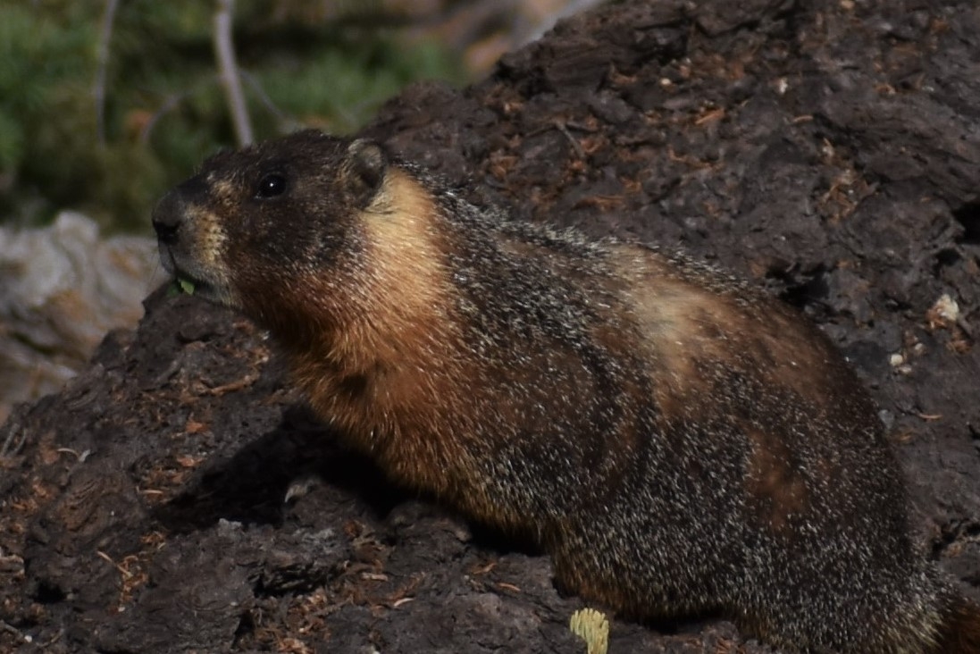
I don’t know on what other criteria you would judge a trip, but I would judge it a success. The thing that made me go back to Ansel Adams was my abortive first attempt. The things that will keep me going back is the wind whistling through the pines, a curious yet afraid marmot, and the raw beauty of a peak towering glacier-covered three-thousand feet beyond a lake full of jumping trout. The thing that will keep me from going back is the body. I’m not sure it’s up to it anymore.
I went to Lake Hodges North Shore, an area that I’ve hiked numerous times before so I am pretty familiar with the trails. After hiking the road for about a mile to the boat ramp parking from the east side, I decided on a new trail at the southeast corner of the lot. I figure it would parallel the main trail and probably join back in so I could do a loop returning on the main trail. I started hiking the trail and then it unexpectedly turned south and headed up the hill instead of staying east. Normally, I would think a spur trail would lead to a street or something but there are no streets in that direction, only lake. It looked like the trail led to an overlook and view of Hodges I have never seen before.
I had my turnback timer set for half an hour so I could keep my end of the day hike to an hour or so to finished before sunset. My turnback timer expired, but I was only a few minutes from the top so I continued. When I summited, I stopped there for some pics but the trail led on. I got the thought that maybe the trail doubles back around the hill and along the shoreline, but it could just as easily have dead-ended. I saw plenty of tire tracks and footprints, too many I think for an obscure out and back trail, but I hadn’t seen another person from the time I set foot on the trail. The sun was already dipping behind clouds over the hills to the west but I took the gamble and the gamble paid off. The trail looped back around the hilltop following the shoreline. I found the trail exit at the southeast corner of the parking lot just beyond the large boat ramp. I started the hike with expectations of dullness and ended up with a little adventure. It’s an unexpected pleasure to find something different in each outing.
Note: Pictures from the particular hike described look rather blue including the feature image. I did not use a blue filter, rather I took indoor pictures the night before and set the white balance to neon lighting. I forgot to turn it back, so in a few of the exposures, you are viewing a neon lit world.
Okay. I have to come clean. I read the weather report of rain followed by overnight temps in the teens. Although I could hear the call of nature, it was the anticipation of the call of nature four times in the middle of the night in subfreezing weather that told me to wait until next time to take spectacular sun-on-the-peak in the reflection-of-the-lake pictures. A man has got to know his limitations, run his own race, stay within himself, ride his own ride, hike his own hike. I still went on the trip but elected to do day hikes instead. I hiked in with the group I intended to backpack with but turned around about six miles into the trip and hiked out by myself. I spent the next day doing hikes in the Bristlecone Pine forest.
The world is opening up again but there are still many concessions to COVID. If you travel, make sure you bring your mask or you won’t be allowed in. To anything. I’m sure in a pinch, you could wrap a bandana or scarf or something around your face, but if you anticipate needing any service or any interaction with anyone indoors, bring your mask. If you are worried about the disease itself, bring hand sanitizer. Some places have it and some places don’t. I will let you know in a week or so if I managed to escape.
The biggest concession on the hike was the closure of the road to vehicles. We had to walk 3.5 miles just to get to the trailhead. And then I had to walk the 3.5 miles out. For me, that meant over half of my hike was walking the road from the parking lot to the trailhead. More on that later though. All the visitor centers are closed. So don’t expect any support. I imagine this will change in the next week or two.
The other big concern was conditioning, or more accurately, lack of it. Today, walking is painful, my calves are completely worked. Judging by when it hurts the most, I think it’s the downhill more than the uphill that worked them the most. Surprisingly, my wind and my heart rate felt pretty good even on the eleven thousand foot hikes in the Bristlecone Forest. My feet held up and my back was fine, despite problems during my few training hikes (Daley Ranch, https://www.thetembo.com/clip/2020/05/24/stanley-peak/ Daley Ranch 2 https://www.thetembo.com/clip/2020/05/28/daley-ranch-addendum/ , and Daley Ranch 3 https://www.thetembo.com/clip/2020/05/31/daley-ranch-3/). I think basketball must have been sufficient training in the past because I didn’t have this problem on previous hikes but not playing is another concession to COVID.
On the first day, I hiked Shadow Creek about halfway before turning back. I did the easy half, descending from 9250 ft elevation at the parking lot, to about 8400 feet along the river, with my friends. But then I had to come back. So I did about twelve miles total and close to a thousand-foot elevation gain, though most of it was on the road. The road back by myself on this hike compared to the trip I took two years ago is a study in contrasts. Two years ago, I stood on a packed bus that weaved in and out of heavy traffic for the slow ride to the trailhead. Instead of squeaking brakes and exhaust, I had the road entirely to myself. I could hear birds chirping, water running, wind whistling through the trees, and smell perfumed plants. Several times, I stopped on the road to take pictures of the Minarets in the distance. A couple of scooters scooted by. Two guys on electric bicycles went flying past. Their batteries died on the uphill and I ended up catching up to them pushing their bikes complaining about technology. But that was it.
On the second day, I drove to Bristlecone Forest. The Bristlecone Forest is on the other side of Owen Valley. It’s about an hour’s drive from Bishop to the visitor center at Schulman Grove. The gates were open but the visitor center was closed. I did the four-mile loop trail through the grove. It’s well-marked with mile markers, has strategically placed benches, and a self-guided tour but no brochures or maps stocked to tell you what they want you to see.
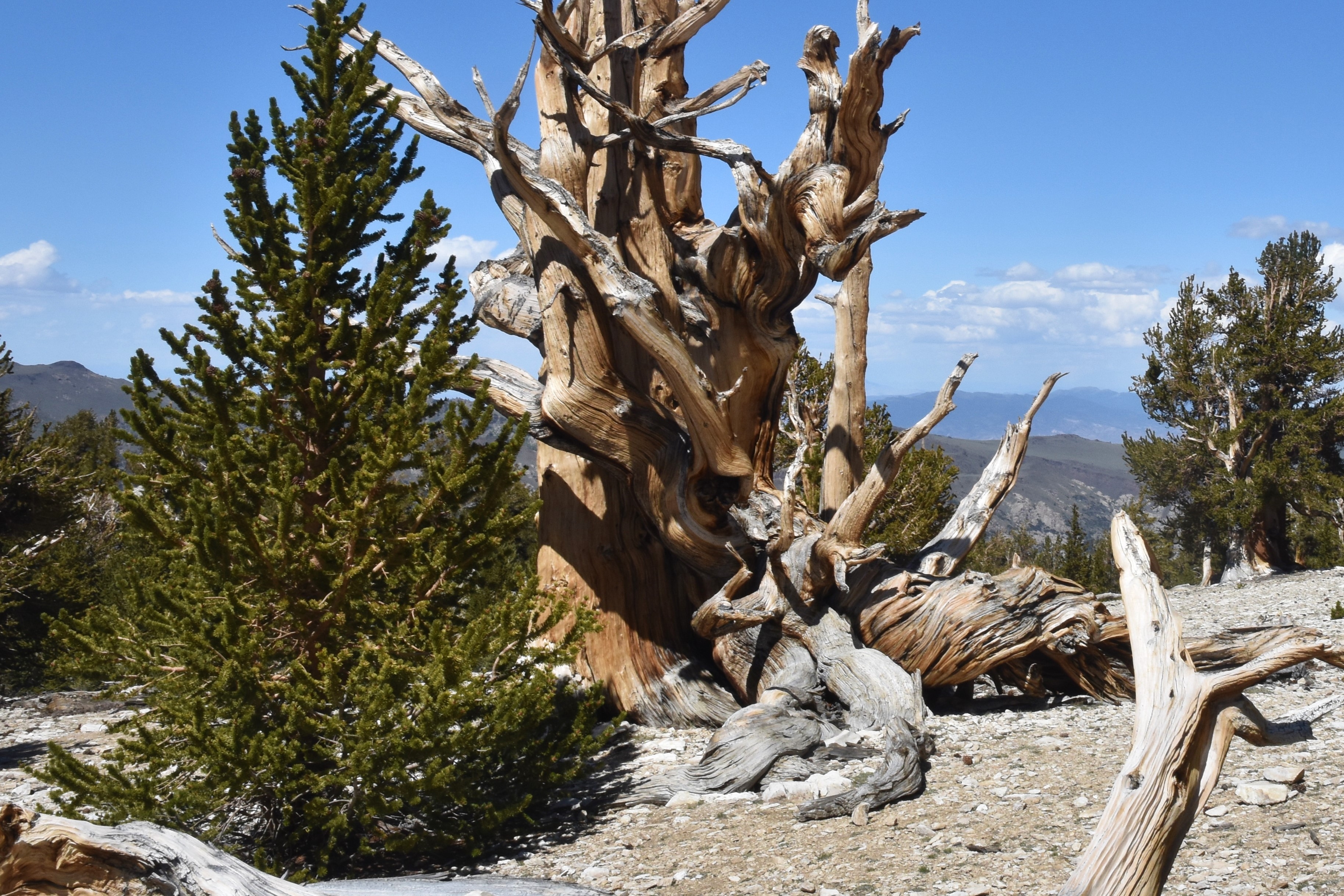
Trees dot the distant hills seemingly spaced like a planned forest without any undergrowth. The wildflowers that do grow are all miniaturized. In addition to their incredible longevity, Bristlecones have an amazing range of deep colors from tan to red to brown, twisted wood particularly as they age, and haunting shapes.
I drove the eleven miles of unpaved road to Patriarch Grove over the eleven thousand foot mark. There are a couple of steep grades, at least from the point of view of a Prius C. The road is well-graded with only the occasional washboard. The last mile is a single-vehicle rough but not uneven road. I had to slow down to the five to ten mph range to get through that stretch without rattling pieces of the car off onto the road.
There are two short loop trails. One through the grove about a quarter-mile long and the other to an overlook, about a half-mile. Given the time of year and lack of atmosphere at that altitude, you might be worried about sunburn. But with temperatures in the mid-forties and gusty wind, I didn’t have any skin exposed to burn. The grove is right at the tree line. At eleven thousand feet, there is not much growing. It’s easy to see why the bald mountain is called White Mountain.
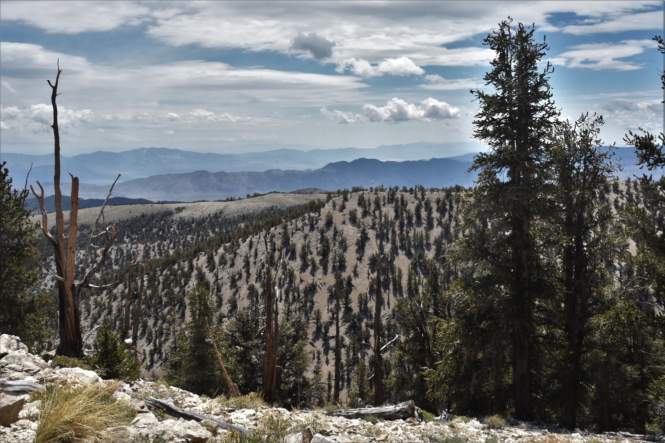
The views from the White Mountains are incredible. To the west, you can see hundreds of miles of the Eastern Sierras. To the east, the entire Great Basin unfolds out as far as you can see, including views of salt flats and sand dunes in Death Valley. It’s a big sky country that a camera can only begin to catch. That’s my way of telling you, you should go see it for yourself.


 for my earlier experience. On the north side of the river, there was a decent crowd with people practicing some sketchy social distancing. But past the first lifeguard tower on the south side, the distance grew to about a hundred feet of social distance, and once past the last lifeguard tower, the beach was as empty as I have seen it on a summer day. Not much of a surf so no boarders to be seen.